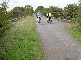
The Brampton Valley Way is a 14-mile (23 km) rail trail built on the way of the former Northampton to Market Harborough Railway in Northamptonshire, England. It forms what trail managers, Northamptonshire County Council, describe as a linear park.
The railway line was closed in 1981 and the 13-mile (21 km) Northamptonshire section was purchased by Northamptonshire County Council with grant aid from the Countryside Commission in 1987, when work began on developing it as a linear park. The 1-mile (1.6 km) section north of the county boundary is owned by Leicestershire County Council. Management of the complete route is now undertaken by Leicestershire County Council, West Northamptonshire Council, and Sustrans.
The Brampton Valley Way, from Boughton Crossing in Northampton to Little Bowden Crossing in Market Harborough, was opened in the spring of 1993 and provides recreational access for cyclists and walkers. Further developments to enhance access continue alongside everyday management of the site. The Way forms an offroad section of the Sustrans National Cycle Network Route 6.
There are two former railway tunnels on the route, Kelmarsh (322 yards or 294 metres) and Oxendon (462 yards or 422 metres). The tunnels are unlit and so can be quite an experience to travel through, although alternative routes over the tunnels are provided.
A section of the Brampton Valley Way runs adjacent to the Northampton & Lamport Railway. The railway is separated from the linear park by a stout safety fence. As the railway extends, so the fence will be erected first to protect members of the public from the works. The Midshires Way passes through the Brampton Valley Way.
and 27 Related for: Brampton Valley Way information
The BramptonValleyWay is a 14-mile (23 km) rail trail built on the way of the former Northampton to Market Harborough Railway in Northamptonshire, England...
The former "up" line tunnel at Kelmarsh is open as part of the BramptonValleyWay, a linear park which runs from Boughton level crossing on the outskirts...
converted in such a way that it can be easily converted back into a signal box if whenever required in the future. The BramptonValleyWay is a "linear park"...
drivers. The former "up" line tunnel at Oxendon is open as part of the BramptonValleyWay, a linear park which runs from Boughton level crossing on the outskirts...
route as a whole forms a part of the National Cycle Network, as the BramptonValleyWay. As early as 1897, Northamptonshire would have had its own Channel...
Northamptonshire with sources at Naseby and Sibbertoft respectively. BramptonValleyWay, the former Northampton to Market Harborough Railway, is now a car...
Tunnel is a former railway tunnel at Kelmarsh now open as part of the BramptonValleyWay. Between 1859 and 1960 the village was served by Kelmarsh railway...
former railway tunnel at Great Oxendon is now open as part of the BramptonValleyWay. Between 1859 and 1960 the village was served by Clipston and Oxendon...
Midlands. After passing through Northampton the route follows the BramptonValleyWay for 14 miles (23 km) to Market Harborough, first opened in 1993 it...
pub. The "Brampton View" care village for the elderly opened in 2008. Boughton Crossing is also the southern end of the BramptonValleyWay, part of which...
Rambla de Sants, Barcelona Turia Gardens (Jardín del Turia), Valencia BramptonValleyWay in Northamptonshire and Leicestershire, England Eastside City Park...
National Cycle Network Route 6. The path continues south following the BramptonValleyWay, a long and narrow recreation area on the route of the former railway...
from Downtown Brampton to Mount Pleasant GO Station. Brampton Transit is connected with Milton Transit to the west, Mississauga's MiWay to the south,...
Northamptonshire. Between Northampton and Market Harborough it follows the BramptonValleyWay along the route of a disused railway line, passing through two tunnels...
running very near or within the Credit River valley, although it only runs through the valley itself within Brampton today. The southern portion between Burnhamthorpe...
villages. Aylsham Brampton Buxton Lamas Little Hautbois Great Hautbois Coltishall Hoveton Wroxham Cycling on the Bure Valley path The Bure Valley path 52°45′30″N...
Creek valley until reaching Brampton's downtown, where it passes landmarks such as Gage Park, Brampton City Hall, and the Rose Theatre Brampton. At Bovaird...
Shoppers World Brampton is a shopping mall in Brampton, Ontario, Canada. It is host to over 190 stores, including Canadian Tire, Winners and Staples....
Brampton, Ontario, Canada. The line will run along Hurontario Street from Mississauga's Port Credit neighbourhood north to Steeles Avenue in Brampton...
non-numbered and numbered (Peel Regional Roads) in Brampton, Ontario. Most major roads in Brampton are concession roads laid out in the early 19th Century...
the numbered regional roads in Peel Region, Ontario. List of roads in Brampton List of roads in Mississauga "Map of Peel Regional Roads" (PDF). Peel Region...
east–west bus-only roadway. MiWay's routes connect with GO Transit along with Brampton Transit to the north, Oakville Transit to the southwest, Milton Transit...
Ardsley, Bolton on Dearne, Goldthorpe, Thurnscoe, Darfield, Stairfoot and Brampton Bierlow, and many other smaller villages and hamlets. In 1995 the area...
between Brampton West and Brampton South); gains the neighbourhoods of Downtown Brampton, Brampton South and Brampton East from Brampton South. Brampton East:...
 Global Information