This article needs additional citations for verification. Please help improve this article by adding citations to reliable sources. Unsourced material may be challenged and removed. Find sources: "Bournbrook" – news · newspapers · books · scholar · JSTOR(June 2009) (Learn how and when to remove this message)
Human settlement in England
Bournbrook
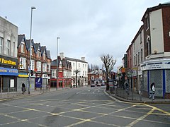
View of Bournbrook High Street (B384 Bristol Road) looking north towards Edgbaston
Bournbrook is an industrial and residential district in southwest Birmingham, England, in the ward of Bournbrook and Selly Park[1] and the parliamentary constituency of Birmingham Selly Oak. Before 2018 it was in Selly Oak Council Ward.[2] Prior to what is commonly termed the Greater Birmingham Act, which came into effect on 9 November 1911, the Bourn Brook watercourse was the North Eastern boundary of Worcestershire,[3] and the area was locally governed by the King's Norton and Northfield Urban District Council.[4]
Bournbrook was once known for its Victorian Leisure Park known as Kerby's Pools.[5] The industry that followed the construction of the canals transformed the ancient manor of Selley. The junction of the Worcester and Birmingham Canal and the Netherton Canal via the Lapal Tunnel created a distribution centre for heavy raw materials from the Black Country.[6] Major industries developed along both sides of the two canals. Terraced housing, for the better off working people, was constructed on the former Selly Hill, Selly Grove, and Selly Oak estates. The High Street provided retail, entertainment, and public services.
The property of Sir Henry Gough Calthorpe of Edgbaston was protected by clauses in the Canal Bill prohibiting the construction of wharves, warehouses, and other buildings along with other restrictive concessions.[7] The Bournbrook rifle range, on the Warwickshire side of the watercourse, was opened in 1860 as the training ground for the Birmingham Rifle Corps later known as the First Volunteer Battalion of the Royal Warwickshire Regiment.[8] Trams from Birmingham initially stopped at Selly Oak Gate, the county boundary on the turnpike road, or at the Gun Barrels Public House. Extended services ran at weekends to Kerby's Pools.[9]
Located adjacent to the main campus of the University of Birmingham, numerous houses in the area have been converted from private housing into HMOs (Houses of Multiple Occupation) for students at the university. In response to this practice, fourteen of Selly Oak's community groups have formed a federation 'CP4SO' (Community Partnership for Selly Oak) to address the major issues that the 'Buy to Let, to convert' might be causing. The Local Action Plan, adopted in July 2001, identifies that: an area of restraint was proposed for the area between Bristol Road, Heeley Road, Raddlebarn Road, and Bournbrook Road. Within this area planning permission for further purpose built student accommodation may be refused. Planning permission is required for the conversion of dwellings for more than six people, or where people do not live as a single household. Planning approval may be refused throughout the Plan area, but particularly within the area of restraint."[10]
^Council, Birmingham City. "Wards and constituencies". birmingham.gov.uk. Retrieved 19 January 2023.
^Council, Birmingham City. "Local Government Boundary Review". birmingham.gov.uk. Retrieved 19 January 2023.
^Hansard: Local Government Provisional Order (No 13) Bill (HC Deb 16 February 1911 volume 21 cc1321-53) https://api.parliament.uk/historic-hansard/commons/1911/feb/16/local-government-provisional-order-no-13#S5CV0021P0_19110216_HOC_383
^Briggs, Asa: History of Birmingham Volume II, Borough and City 1865-1938, (OUP 1952) Chapter V Greater Birmingham
^Upton, Chris: Days of Birmingham's Lake District.(Birmingham Post 14 March 1998).
^White, Reverend Alan: The Worcester and Birmingham Canal – Chronicles of the Cut (Brewin 2005) p53
^White, Reverend Alan: The Worcester and Birmingham Canal – Chronicles of the Cut (Brewin 2005) p13
^Showell, Walter: Dictionary of Birmingham (Walter Showell and Sons 1885) – Volunteers of the present day
^Jenson, Alec G: Birmingham Transport (BTHG 1978) p45
^Birmingham City Council: Selly Oak Local Action Plan (July 2001) p39
Bournbrook is an industrial and residential district in southwest Birmingham, England, in the ward of Bournbrook and Selly Park and the parliamentary constituency...
theories on the rule of elites on his YouTube channel, "Academic Agent". In Bournbrook Magazine, Alexander Adams describes Parvini's book The Populist Delusion...
Birchfield Birmingham City Centre Boldmere Bordesley Bordesley Green Bournbrook Bournville Brandwood End Brindleyplace Bromford Browns Green Buckland...
linked by winding country lanes, with the only visual highlight being Bournbrook Hall, which was built during the Georgian era. The bluebell glades of...
Ariel Motorcycles was a British maker of bicycles and then motorcycles in Bournbrook, Birmingham. It was an innovator in British motorcycling, part of the...
distinctive dark red petrol and oil tanks which were painted in the former Bournbrook cinema opposite the main Ariel factory in Dawlish Road. The engines were...
of England in the Bournbrook district of Birmingham, but which is now an Elim Pentecostal Church. St Wulstan's Church, Bournbrook, was established as...
Calthorpe family offered twenty-five acres (10 hectares) of land on the Bournbrook side of their estate in July. The Court of Governors received the Birmingham...
parishes of Northfield and King's Norton centred on the Georgian-built Bournbrook Hall, where they developed the garden village of Bournville; now a major...
gives its name to Selly Oak ward and includes the neighbourhoods of: Bournbrook, Selly Park, and Ten Acres. The adjoining wards of Edgbaston and Harborne...
in the first match at its new home at the University of Birmingham in Bournbrook. However long-term permissions for a clubhouse and hospitality boxes were...
Birmingham City Council began publishing ward results on 6 May 2022. The Bournbrook and Selly Park by-election was triggered by the resignation of Labour...
Council ward of Bournbrook and Selly Park. Prior to 2018, it was part of the Selly Oak council ward, along with the districts of Bournbrook, Selly Oak, Ten...
along the path of the Worcester and Birmingham Canal, they acquired the Bournbrook estate, comprising 14.5 acres (5.9 ha) of countryside south of Birmingham...
Adams, Alexander (2022-05-06). "Book Review: The Populist Delusion". Bournbrook Magazine. Retrieved 2024-04-22. Amsden, Alice (2012) The Role of Elites...
intended for the erection of a tower in connection with the new buildings at Bournbrook at a cost estimated by the architects at £25,000. The tower, it was suggested...
Cadbury and Bourneville, Bournbrook Publications, 2002. Page 45 D Sharpe, The Railways of Cadbury and Bourneville, Bournbrook Publications, 2002. Page...
reflected in a number of place names. See: Bourn Brook, Cambridgeshire Bournbrook, Birmingham named after the Bourn Brook, a tributary of the River Rea...
The new hospital was part of a £1 billion urban regeneration plan for Bournbrook and Selly Oak which included the construction of a £350 million retail...
Locomotives - Phil Trotter". D Sharpe, The Railways of Cadbury and Bourneville, Bournbrook Publications, 2002. p. 45 "Railway Database". Archived from the original...
held on 2 May 2024 in authorities otherwise without elections scheduled: Bournbrook and Selly Park ward for Birmingham Canford Cliffs ward for Bournemouth...
 Global Information