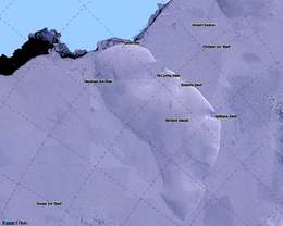
Berkner Island (also known as the Berkner Ice Rise or as Hubley Island) is an Antarctic ice rise, where bedrock below sea level has caused the surrounding ice sheet to create a dome. If the ice cap were removed, the island would be underwater.[1] Berkner Island is completely ice-covered and is about 320 kilometres (200 mi) long and 150 kilometres (93 mi) wide, with an area of 44,000 km2 (17,000 sq mi). It is surrounded by the Filchner-Ronne Ice Shelf. The northernmost point of the Berkner is about 20 kilometres (12 mi) from the open sea. It lies in the overlapping portion of the Argentine and the British Antarctic territorial claims.
The island rises to 869 m (2,850 ft) (975 m or 3,200 ft, according to other sources) and separates the Ronne Ice Shelf from the Filchner Ice Shelf. It is characterized by two domes, Reinwarthhöhe in the north (698 m or 2,290 ft), and Thyssenhöhe in the south (869 m or 2,851 ft). It is indented by three bays on the eastern side, which are, from north to south, the McCarthy Inlet, the Roberts Inlet, and the Spilhaus Inlet. The southern tip is named the Mulvaney Promontory. Gould Bay is on the north coast. Berkner Island is about 150 km (93 mi) west of Luitpold Coast, Coats Land, the closest mainland of Eastern Antarctica. The Hemmen Ice Rise is 17 km (10.6 mi) off the northwest corner of Berkner Island.
^"Flichner Ice Shelf". Archived from the original on 2011-10-15. Retrieved 2012-05-11.
BerknerIsland (also known as the Berkner Ice Rise or as Hubley Island) is an Antarctic ice rise, where bedrock below sea level has caused the surrounding...
Berkner may refer to: BerknerIsland, the southernmost island of the world Berkner (crater), a lunar crater Laurie Berkner (born 1969), American musician...
Lloyd Viel Berkner (February 1, 1905 in Milwaukee, Wisconsin – June 4, 1967 in Washington, D.C.) was an American physicist and engineer. He was one of...
This list includes all islands in the world larger than 2,500 km2 (970 sq mi) and most of the islands over 1,000 km2 (390 sq mi), sorted in descending...
uninhabited island, desert island, or deserted island, is an island, islet or atoll that is not permanently populated by humans. Uninhabited islands are often...
Adelaide Island Astrolabe IslandBerknerIsland Dundee Island D'Urville Island James Ross Island Lockyer Island Joinville Island Snow Hill Island South Orkney...
days from BerknerIsland, 2Nov-31Dec, flown out by ANI. 1998–1999 – Eric Philips, Jon Muir and Peter Hillary pioneer a new route from Ross Island to the...
500 (BerknerIsland)) Bernal Islands Bernard Island Bertha Island Berthelot Islands Green Island (Berthelot Islands) Beslen Island Bielecki Island (64°46′S...
Ellesmere Island to the pole in 49 days 2009: Greenland, crossed the inland ice west to east – 590 km 2010: Crossed Antarctica, from BerknerIsland via the...
Land, Antarctica. It is the third-largest island of Antarctica, after Alexander Island and BerknerIsland. Map all coordinates using OpenStreetMap Download...
minutes from the Northern end of BerknerIsland to the South Pole. She has started further North on BerknerIsland than any other expedition before her...
The Danger Islands (63°25′S 54°40′W / 63.417°S 54.667°W / -63.417; -54.667 (Danger Islands)) are a group of islands lying 13 nautical miles (24 km;...
are Kopaitic Island, Largo Island and the Wisconsin Islands. Nearby features include Bulnes Island and Link Island. The Duroch Islands were discovered...
Signy Island is a small subantarctic island in the South Orkney Islands of Antarctica. It was named by the Norwegian whaler Petter Sørlle (1884–1933)...
Dream Island is an island lying 0.7 km (0.43 mi) south-east of Cape Monaco, off the south-west coast of Anvers Island in Wylie Bay, in the Palmer Archipelago...
Maher Island is a small horseshoe-shaped island lying 10 km (6.2 mi) north of the north-western end of Siple Island, off the coast of Marie Byrd Land...
Gardner Island is a largely ice-free island which lies about 3 km west of Broad Peninsula in the southern Vestfold Hills, in Prydz Bay on the Ingrid Christensen...
on the world's southernmost island reachable from the sea: Ross Island. The southernmost island is said to be BerknerIsland. It is embedded in the ice...
83°S 59°W / -83; -59)[citation needed], about 100 km (60 mi) south of BerknerIsland. The southernmost point of ocean is located on the Gould Coast (84°30′S...
resolution data for the period it covers. A 948 m core was drilled at BerknerIsland by a project managed by the British Antarctic Survey from 2002 to 2005...
Sturge Island is one of the three main islands in the uninhabited Balleny Islands group located in the Southern Ocean. It lies 25 km (16 mi) southeast...
The Possession Islands (71°56′S 171°10′E / 71.933°S 171.167°E / -71.933; 171.167) are a group of small islands and rocks extending over an area of about...
 Global Information