 Global Information
Benvane information
| Benvane | |
|---|---|
| Scottish Gaelic: Beinn Bhàn | |
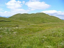 Benvane from its south ridge | |
| Highest point | |
| Elevation | 821 m (2,694 ft)[1] |
| Prominence | 215 metres (705 ft)[2] |
| Parent peak | Ben Ledi |
| Listing | Corbett, Marilyn |
| Naming | |
| English translation | White Mountain[3] |
| Language of name | Gaelic |
| Geography | |
| Location | Stirling, Scotland |
| Parent range | Trossachs |
| OS grid | NN535137 |
| Topo map | OS Landranger 57 |
Benvane (Scottish Gaelic: Beinn Bhàn) is a mountain in the Trossachs, in Stirling council area, Scotland. It lies within Loch Lomond and The Trossachs National Park and the Queen Elizabeth Forest Park,[4] and the summit is on the western boundary of the Trossachs National Nature Reserve.[5] It is 821 metres (2,694 ft) high, and is classified as a Corbett, being joined by a ridge to the neighbouring Corbett of Ben Ledi.[3]
Benvane may be climbed by several routes, which can be combined to make for a circular route. From the south the summit can be reached via the 6 km-long ridge that connects it to Ben Ledi: the bealach between the two peaks can be reached via Ben Ledi itself or directly: either from the Stank Glen on the west side of this ridge, ascending from the shores of Loch Lubaig; or from Brig o' Turk via the Glen Finglas reservoir and Glen Casaig. Brig o' Turk also serves as the start point for a route ascending directly to Benvane's summit via its south ridge. On the northern side of the hill there are also routes from Strathyre, and from Glen Buckie near Balquhidder via a route up the hill's north ridge.[3]
The Ben Ledi-Benvane ridge marks the boundary between West Strathyre estate (owned by Forestry and Land Scotland),[1][6] and Glen Finglas Estate, which is owned by the Woodland Trust.[7]
- ^ a b Ordnance Survey Landranger 1:50000 Series. Sheet 57: Stirling & The Trossachs.
- ^ "Benvane". hill-bagging.co.uk. Retrieved 4 August 2020.
- ^ a b c Rob Milne & Hamish Brown, ed. (2016). The Corbetts and Other Scottish Hills. Scottish Mountaineering Trust. p. 49. ISBN 9780907521716.
- ^ "Queen Elizabeth Forest Park". Forestry and Land Scotland. Retrieved 4 August 2020.
- ^ "The Great Trossachs Forest NNR". Scottish Natural Heritage. Retrieved 4 August 2020.
- ^ "West Strathyre Land Management Plan" (PDF). Forestry and Land Scotland. Retrieved 4 August 2020.
- ^ "Property Details: Glenfinglas". Who Owns Scotland. Retrieved 4 August 2020.