Global Information Lookup Global Information

Beliatta Polling Division information


Beliatta
Polling Division
Location of Beliatta
Coordinates: 6°05′26″N 80°42′23″E / 6.090694°N 80.706439°E
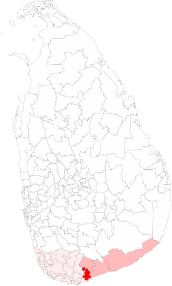
 / 6.090694; 80.706439
CountrySri Lanka
ProvinceSouthern Province, Sri Lanka
Electoral DistrictHambantota Electoral District
Area
 • Total141.63 km2 (54.68 sq mi)
Population
 (2012)[1]
 • Total75,010
 • Density530/km2 (1,400/sq mi)
ISO 3166 codeEC-09B

The Beliatta Polling Division is a Polling Division in the Hambantota Electoral District, in the Southern Province, Sri Lanka.

  1. ^ "Census of Population and Housing 2012". statistics.gov.lk. Department of Census and Statistics, Sri Lanka. 2012.

and 3 Related for: Beliatta Polling Division information

Request time (Page generated in 0.775 seconds.)

Beliatta Polling Division

Last Update:

The Beliatta Polling Division is a Polling Division in the Hambantota Electoral District, in the Southern Province, Sri Lanka. The winner of Beliatta has...

Word Count : 596

Mahinda Rajapaksa

Last Update:

as SLFP organiser for Beliatta in 1968. Rajapaksa contested the 1970 general elections as the SLFP candidate for the Beliatta constituency and was elected...

Word Count : 11537

1977 Sri Lankan parliamentary election

Last Update:

seats in the National State Assembly 85 seats were needed for a majority Winners of polling divisions. UNP in green, TULF in yellow and SLFP in blue....

Word Count : 631

PDF Search Engine © AllGlobal.net