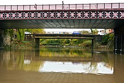
Bedminster Bridge is a road bridge in Bristol, England, that crosses the New Cut of the River Avon. There are actually two adjacent parallel bridges, the Bedminster Old Bridge downstream and the Bedminster New Bridge upstream, which form part of a gyratory system carrying the A38 road. The Old Bridge dates back to 1883, when it replaced the previous Harford's Bridge, and was grade II listed in 1994. The New Bridge was added in the 1960s.[1][2]
The Old Bridge is built of iron and pennant stone, with a shallow, elliptical arch. The sides have an iron cross lattice with applied flower casts and vertical chain-moulded struts, and above it a balustrade of interwoven ropes beneath a heavy rope handrail. At either side are abutments, surmounted by panelled ashlar piers to the balustrades.[1]
The original Harford's Bridge was a cast iron bridge built in 1809 at the time of the construction of the New Cut. During the demolition of Harford's Bridge and the construction of Bedminster Old Bridge, a temporary bridge was erected alongside. Once it had fulfilled its purpose, the temporary bridge was lifted off its base by two barges on a rising tide, and moved upstream to a new location, where it still exists as the Langton Street Bridge.[2]
^ ab"Bedminster Bridge". National Heritage List for England. Historic England. Retrieved 9 December 2022.
^ ab"The New Cut 2". Bristol City Council. Retrieved 9 December 2022.
BedminsterBridge is a road bridge in Bristol, England, that crosses the New Cut of the River Avon. There are actually two adjacent parallel bridges, the...
Langton Street and St. Luke's Road, the bridge was said to be a temporary route while the nearby BedminsterBridge was rebuilt. Langton Street has since...
times on BedminsterBridge, another double bridge, before crossing over to Spike Island on a bridge known as 'the blue caboose' or Ostrich Bridge, after...
Bristol, the original route from BedminsterBridge ran up Redcliffe Hill and then along Redcliff Street to Bristol Bridge. In the 1950s Redcliff Street was...
between 1804 and 1809 the pipe was diverted to cross the cut via BedminsterBridge. The present pipe runs under a railway line, and it is believed that...
Bedminster railway station is on the Bristol to Exeter line and serves the districts of Bedminster and Windmill Hill in Bristol, south-west England. It...
BedminsterBridge. Windmill Hill City Farm was set up in 1976 on land cleared as part of this scheme. For nearly 20 years, the link from Bedminster Bridge...
Bedminster Town Hall is a former events venue in Cannon Street in Bedminster, a suburb of Bristol in England. The building is currently in use as a furniture...
Bridge is a historic wooden covered bridge located on Wismer Road crossing Cabin Run (creek) upstream from the Cabin Run Covered Bridge in Bedminster...
the northbound direction narrowing to two local lanes, before entering Bedminster. Here, I-287 intersects I-78 at the Vincent R. Kramer Interchange, where...
Oldwick. At exit 29, I-287, US 202, and US 206 interchange with I-78 in Bedminster. At this point, in Somerset County, exits 33, 36, and 40 are for county...
Second World War, Bristol Bridge was an important transport hub. It was the terminus of tram routes to Knowle, Bedminster and Ashton Gate, and other...
located in the U.S. state of New Jersey and includes the municipalities of Bedminster, Bernardsville, Bernards Township, Far Hills, and Peapack-Gladstone. The...
again. Along this distance it forms the boundary between Haycock and Bedminster Townships. As the stream widens into the vast Lake Nockamixon, the current...
between Portishead and Temple Meads in peak periods, possibly calling at Bedminster and Parson Street. The line was built in the 1860s but closed to passenger...
The balloon makers Cameron Balloons are near to the fiesta site, in Bedminster, and make many of the special shaped balloons, which have included Rupert...
permanently. A tidal by-pass was dug for 2 miles through the fields of Bedminster for the river, known as the "River Avon New Cut", "New Cut", or simply...
Ferry Bridge is a footbridge in Bristol, England, that crosses the New Cut of the River Avon. It is an ornate steel lattice suspension bridge with timber...
Parson Street railway station serves the western end of Bedminster in Bristol, England. It also serves other surrounding suburbs including Bishopsworth...
 Global Information