Preview warning: Page using Template:Infobox station with deprecated parameter "disabled". Replace with "accessible".
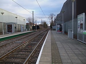
Beddington Lane tram stop is a stop on the Tramlink tramway. There was previously a railway station on this site, on the single track line from Wimbledon to West Croydon, which closed in 1997 in order for it to be converted for Tramlink use. The stop is accessible from the east from Beddington Lane, and also from the pathway leading to the west and south. In late 2014, the track immediately to the west of the tram stop was doubled, though further west the bridge carrying trams over the main line at Mitcham Junction is still single-track.
View in 1983The tram stop
It is one of two Tramlink stops within the London Borough of Sutton, the other being Therapia Lane.
^"Tram Stop Usage 2009-10 (FOI)" (XLS). Tramlink annual passenger performance 2009-2010. Transport for London. 18 August 2011. Retrieved 28 November 2012.
^"Tramlink numbers 2010-2011" (PDF). Tramlink annual passenger performance 2010-2011. Transport for London. 28 March 2012. Retrieved 28 November 2012.
and 29 Related for: Beddington Lane tram stop information
BeddingtonLanetramstop is a stop on the Tramlink tramway. There was previously a railway station on this site, on the single track line from Wimbledon...
Tramlink stops within Sutton borough, the other being BeddingtonLane. Just to the west of the stop is Therapia Lane Depot Staff Halt, a two platform stop used...
closed with the line after the last train ran on 31 May 1997. BeddingtonLanetramstop was built on the site. 51°23′23″N 0°08′31″W / 51.38961°N 0.14199°W...
Therapia Lane depot is a tram depot, situated in the London Borough of Sutton between Therapia Lane and BeddingtonLane. Built on the site of former railway...
Beddington is a suburban settlement in the London Borough of Sutton on the boundary with the London Borough of Croydon. Beddington is formed from a village...
Mitcham tramstop is a Tramlink stop in Mitcham in the London Borough of Merton. The stop is located between Belgrave Walk and Mitcham Junction. It is...
0°04′51″W / 51.364188°N 0.080703°W / 51.364188; -0.080703 Lloyd Park tramstop is on the edge of Lloyd Park in the London Borough of Croydon in the southern...
Lebanon Road tramstop is a light rail stop in the London Borough of Croydon in the southern suburbs of London. It serves the residential area along Addiscombe...
Wellesley Road tramstop is a halt on the Tramlink service in the London Borough of Croydon. It consists of a single platform on Wellesley Road at the...
enlargement of the current Therapia Lane site, as well as sites near the Elmers End and Harrington Road tramstops, were shortlisted. During July 2013...
station and tramstop. "London and South East" (PDF). National Rail. September 2006. Archived from the original (PDF) on 6 March 2009. "TramStop Usage 2009-10...
Addington to Wimbledon via Croydon, and was on the approach to Sandilands tramstop soon after 06:00. The speed limit dropped from 80 km/h (50 mph) to 20 km/h...
Wandle Park tramstop is a stop adjacent to Wandle Park in the London Borough of Croydon in the southern suburbs of London. It serves the residential...
West Croydon is a combined railway, bus station and tramstop in Croydon, south London. It is served by National Rail, London Overground, Tramlink and...
Dundonald Road tramstop is a stop on the Tramlink service to the south of Wimbledon town centre, in the London Borough of Merton. Access is direct from...
070329 Blackhorse Lanetramstop is a light rail stop in the London Borough of Croydon in the southern suburbs of London. The tramstop is located on a...
Phipps Bridge tramstop is a stop on the Tramlink service in the London Borough of Merton. The stop is named after Phipps Bridge Road, an adjacent residential...
stations on the Network Rail Main Line Services that are open and Tramlink stops. Contents: Top 0–9 A B C D E F G H I J K L M N O P Q R S T U V W X Y Z...
Waddon Marsh tramstop is a stop on the Tramlink service serving the area between Waddon and Croydon in the London Borough of Croydon. It is close to...
Belgrave Walk tramstop is a stop on the Tramlink service near Mitcham in the London Borough of Merton. The stop is named after Belgrave Walk, an adjacent...
Ampere Way is a tramstop in the London Borough of Croydon, serving the Purley Way commercial area. Tramlink trams serve the stop, which is located opposite...
station in the centre of Wimbledon in London for London Underground, London Trams and National Rail services, and is the only station in London that provides...
Harrington Road tramstop is a light rail stop in South Norwood in the London Borough of Croydon in the southern suburbs of London. Harrington Road is...
towards Wimbledon and Therapia Lane. Church Street signage Tram no. 2530 at Church Street stop in August 2015 "TramStop Usage 2009-10 (FOI)" (XLS). Tramlink...
0°02′35″W / 51.35455°N 0.04314°W / 51.35455; -0.04314 Gravel Hill tramstop is a light rail stop serving Addington, in the London Borough of Croydon in the southern...
Junction is the main railway and tram station in Beckenham in the London Borough of Bromley, south London. The railway stop is on the Chatham Main Line, 8 miles...
East Croydon is a railway station, tramstop and associated bus station in Croydon, Greater London, England. It is located in Travelcard Zone 5. At 10 miles...
 Global Information