The Beaverhead River is an approximately 69-mile-long (111 km) tributary of the Jefferson River in southwest Montana (east of the Continental Divide).[1] It drains an area of roughly 4,778 square miles (12,370 km2). The river's original headwaters, formed by the confluence of the Red Rock River and Horse Prairie Creek, are now flooded under Clark Canyon Reservoir, which also floods the first 6 miles (9.7 km) of the river.[2] The Beaverhead then flows through a broad valley northward to join the Big Hole River and form the Jefferson River.[3] With the Red Rock River included in its length, the river stretches another 70 miles (110 km), for a total length of 139 miles (224 km), one of the more significant drainages of south-western Montana.
The name of the Beaverhead originates from Beaverhead Rock on the middle river. This rock formation was recognized by Sacajawea when the Lewis and Clark Expedition passed the area in 1805. There were also many beavers in the area at the time, but the name does not originate from the animal. In 1805, Captain Meriwether Lewis traveled up the Jefferson and Beaverhead first, but when the rest of the expedition came, a sign Lewis had left at the confluence of the Beaverhead and Big Hole telling them to follow the Beaverhead had been cut down by a beaver, and the expedition traveled up the Big Hole instead. As a result, the swifter current of the Big Hole swamped two of their canoes before they could travel back down to the confluence.[4]
Together with the Red Rock River, the Beaverhead forms the uppermost headwaters of the Missouri River, the longest tributary of the Mississippi River.
The river is a Class I water from the Clark Canyon Dam to its confluence with the Jefferson River for the purposes of public access for recreational purposes.[5]
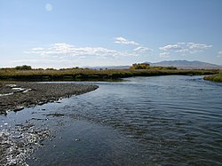
Drone Shot of Beaverhead River[6]
^"Beaverhead River". Geographic Names Information System. United States Geological Survey, United States Department of the Interior.
^"Beaverhead River". Montana Fishing Guide. Archived from the original on 8 November 2009. Retrieved 2009-11-10.
^"Beaverhead River and Big Hole River". Montana Fish, Wildlife and Park Service. Archived from the original on 8 November 2009. Retrieved 2009-11-10.
^Huser, Verne (2004). On the river with Lewis and Clark. Texas A&M University Press. p. 89. ISBN 1-58544-344-1.
^Stream Access in Montana Archived 2009-03-10 at the Wayback Machine
^McLean, Bryce. "Drone Shot of the Beaverhead River". guide-x.io. Archived from the original on 2021-05-06. Retrieved 2021-05-06.
The BeaverheadRiver is an approximately 69-mile-long (111 km) tributary of the Jefferson River in southwest Montana (east of the Continental Divide)...
The Ruby River is a tributary of the BeaverheadRiver, approximately 76 mi (122 km) long, in southwestern Montana in the United States. It rises in the...
is known as the BeaverheadRiver. It is joined by the Ruby River above the town of Twin Bridges and converges with the Big Hole River to form the Jefferson...
unfragmented rivers List of longest undammed rivers List of river name etymologies List of rivers by age List of rivers by discharge List of rivers by length...
Lewis and Clark's confluence, "following the Jefferson River to the BeaverheadRiver to Red Rock River, then Red Rock Creek to Hell Roaring Creek."[citation...
The Big Hole River is a tributary of the Jefferson River, approximately 153 miles (246 km) long, in Beaverhead County, in southwestern Montana, United...
northeast to become the BeaverheadRiver; and finally joins with the Big Hole to form the Jefferson River. The Firehole River, which originates in northwest...
formation of Leaton Gulch, Grouse Peak, northern Lost River Range, Idaho: Relation to Beaverhead Impact Structure, in Hughes, S.S., and Thackray, G.D....
Mississippi rivers. Missouri River Jefferson RiverBeaverheadRiver Blacktail Deer Creek Ruby River Red Rock River Big Hole River Wise River Boulder River Roe...
The McKenzie River dory, or drift boat, is an adaptation of the open-water dory converted for use in rivers. A variant of the boat's hull is called a modified...
Beaverhead Rock, also known as Point of Rocks, is a rock formation overlooking the BeaverheadRiver in Montana protected as Beaverhead Rock State Park...
flows into Red Rock River and then into Clark canyon reservoir, where it joins the BeaverheadRiver and then the Big Hole River, before ultimately joining...
Montana in the United States. It rises in the Beaverhead National Forest in the Pioneer Mountains in Beaverhead County. It flows NNW through the mountains...
tributary of the BeaverheadRiver, approximately 38 miles (61 km) long, in southwest Montana, United States. It rises in the Beaverhead National Forest...
the Missouri River. Hell Roaring Creek is the most distant point in the Mississippi River system and, combined with its downstream rivers, marks the starting...
uppermost fur-trading post on the Missouri River. In the 1850s, settlers began moving into the Beaverhead and Big Hole valleys from the Oregon Trail and...
The Beaverhead Mountains, highest point Scott Peak, el. 11,393 feet (3,473 m), are a mountain range straddling the Continental Divide in the U.S. states...
River Missouri River Jefferson RiverBeaverheadRiver Red Rock River Ruby River Big Hole River Wise River Madison River Firehole River Gibbon River Gallatin...
Arctic grayling have been reestablished in the upper Ruby River, a tributary of the BeaverheadRiver. The native range formerly extended south into the Great...
Drift Boat is an evolution of the open-water dory, converted for use in rivers. The design is characterized by a wide, flat bottom, flared sides, a narrow...
Ackley Lake Anaconda Smelter Stack Beaverhead Rock Beavertail Hill Big Arm Black Sandy Brush Lake Chief Plenty Coups Clark's Lookout Cooney Council Grove...
 Global Information