Maybole Creek, The Beardy Water, Beardy River, The Beardy Waters[1]
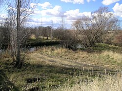
Beardy Waters at Stonehenge, NSW
Etymology
In honour of two bearded stockmen, William Chandler and John Duval[2]
Location
Country
Australia
State
New South Wales
IBRA
New England Tablelands
District
New England
Municipality
Glen Innes Severn
Physical characteristics
Source
Waterloo Range, Great Dividing Range
• location
near Glen Innes
• elevation
1,200 m (3,900 ft)
Mouth
confluence with the Severn River (NSW)
• elevation
884 m (2,900 ft)
Length
76 km (47 mi)
Basin features
River system
Macintyre River. Murray–Darling basin
[3]
Beardy Waters, a watercourse and part of the Macintyre catchment within the Murray–Darling basin, is located in the Northern Tablelands region of New South Wales, Australia.
^"Beardy Waters". Geographical Names Register (GNR) of NSW. Geographical Names Board of New South Wales. Retrieved 13 February 2013.
^Cite error: The named reference ReferenceA was invoked but never defined (see the help page).
^"Map of Beardy Waters, NSW". Bonzle.com. Retrieved 14 February 2013.
BeardyWaters, a watercourse and part of the Macintyre catchment within the Murray–Darling basin, is located in the Northern Tablelands region of New...
heritage-listed closed railway bridge that carried the Main Northern Line across BeardyWaters, situated 694.371 kilometres (431.462 mi) from Central station, near...
crossing Wyaldra Creek at Gulgong Yarraford Rail Bridge over BeardyWaters, crossing BeardyWaters near Glen Innes Yass River railway bridge, Yass, crossing...
waterway. The Darling is in poor health, suffering from over-allocation of its waters to irrigation, pollution from pesticide runoff, and prolonged drought. During...
who on this occasion were within comparatively easy reach of the head waters, could have seen a new inland river at that time without mentioning the...
Boggabilla Weir. The Macintyre River, together with Pike Creek, the Mole, Beardy, Severn (Queensland), Severn (New South Wales), and Dumaresq rivers are...
Street (New England Highway) (A15 south) – Armidale, Tamworth, Newcastle BeardyWaters 415 258 Bridge over the river (bridge name unknown) Mann River 524 326...
the Mitta Mitta River with the Murray River is now submerged beneath the waters of Lake Hume for a large part of the time. The catchment area of the Mitta...
times, particularly before the advent of large-scale river regulation, the waters at the Murray Mouth are almost invariably slow and shallow. As of 2010[update]...
with gupna meaning "deep waterholes"; and Gaiyila, meaning "father of waters". Hamilton Hume and William Hovell explored the area in 1824, naming the...
the Barwon, which becomes the Darling River further west near Bourke. The waters of the Darling River then flow south through the arid far west of NSW. The...
Digital Atlas of Australia. Retrieved 18 October 2014. "Avoca - Angling Waters". Fishing guides. Department of Sustainability and Environment, Government...
megalitres (42,000×10^6 cu ft) located near Wellington which impounds the waters of the Wambuul Macquarie River and its tributaries the Cudgegong River and...
Australian Government. "Loddon River (South)". A guide to the inland angling waters of Victoria. Department of Environment and Primary Industries, Victorian...
 Global Information