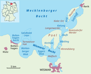
The Bay of Wismar[1] or more commonly Wismar Bay or Wismarbucht is a well sheltered multi-sectioned bay in the southwestern Baltic Sea, in Mecklenburg-Vorpommern, Germany, and is considered the south-central part of the much larger arm of the Baltic known as the Mecklenburg Bay (or Mecklenburg Bight, for its long narrow bent shape)—a long fingerlike gulf oriented to the west-southwest (WSW) from the (central) Baltic proper. Wismar bay is considered one of the finest natural harbors[2] on the Baltic, and served as the destination for much seaborne shipping until circa the 1910s when its minimum depths of 5 meters (16 ft) became too shallow for larger more modern ships. Today, because of the shallow sheltered waters the bay is the subject of much research via underwater archeology
There are four lobe like parts of the Bay of Wismar which are themselves bays on its southern shores, each separated by a north intruding headland from the others (see maps at right) and a broad channel running northwest to southeast parallel to the line formed by the tips of the four bounding headlands. The tips of the four headlands are remarkably well aligned and very closely co-linear spanning 10.80 mi (17.38 km) northwest to southeast tip to tip[3] along the channel along which the inlets are respectively Boltenhagen Bay, Wohlenberger Wiek, Eggers Wiek, and the inner bay. A channel, the Breitling between Poel island and the mainland is accounted part of the bay as well, which in its northern limit is the north shore of the island.
From the western headland to the eastern shore of the inner bay is 13.4 miles (21.6 km).[3] All of the waters are bounded by Poel Island on one side—a large mainly agricultural and recreational island sheltering the most easterly parts of bay (the inner Bay of Wismar and the small coastal seaport) along most of its northern edge.
The sheltered anchorage extends over a rhombus shaped area in the southerly lee of Poel island roughly 3 miles (4.8 km) N-S[3] in the inner anchorage narrowing to 1.75 miles (2.82 km) N-S[3] between the innermost headland and southernmost tip of the island and roughly 5–6 miles (8–10 km) that distance WNW to ESE.[3]
In general, the main waters of the bay are located to the west, southwest and south relative to Poel Island which is wholly within Wismar Bay. The northern tip of the island in a line westerly to the headland of Großklützhöved (3.35 mi (5.39 km) north[3] of the village of Klütz) forms the mouth of the bay.
Main ports: Wismar, 20 mi (32 km) by rail north of Schwerin.[2]
^Kohl, Horst; Marcinek, Joachim and Nitz, Bernhard (1986). Geography of the German Democratic Republic, VEB Hermann Haack, Gotha, p. 47. ISBN 978-3-7301-0522-1.
The BayofWismar or more commonly WismarBay or Wismarbucht is a well sheltered multi-sectioned bay in the southwestern Baltic Sea, in Mecklenburg-Vorpommern...
largest part of the Baltic to the east. The Bayof Mecklenburg, which includes the BayofWismar and the Bayof Lübeck, connects to the Bayof Kiel in the...
boundaries of the BayofWismar on the German coast. The northern coast of the island is also on the south side of the large gulf known as the Bayof Mecklenburg...
(Warnow), a bay at the mouth of the River Warnow in the Baltic Breitling (BayofWismar), a bay between the mainland and the Baltic Sea island of Poel Breitling...
(secondary coordinates) The 54th parallel north is a circle of latitude that is 54 degrees north of the Earth's equatorial plane. It crosses Europe, Asia,...
Special Area of Conservation known as WismarBay and the bird reserve of "WismarBay and Salzhaff". Nature and bird protection in the WismarBay (pdf, 180...
small uninhabited island near the island Poel north of Gollwitz, a district of the municipality of Poel island. It is approximately 800 metres long, 500...
kilometres (4 miles) south of the BayofWismar in Mecklenburg-Vorpommern, Germany. The only remnants of the ruined castle are parts of an earthen wall. Some...
in the Bayof Mecklenburg in the Baltic Sea. It lies approximately 4.5 kilometres (2.8 mi) north of the city ofWismar, south of the island of Poel. The...
Rerik was one of the Viking Age multi-ethnic Slavic-Scandinavian emporia on the southern coast of the Baltic Sea, located near Wismar in the present-day...
maritima). Weidenschwanz is part of the WismarBay Special Area of Conservation and the bird reserve of "WismarBay and Salzhaff". Biotopbogen zur Insel...
maritima). /ref> Grot Deil is part of the WismarBay Special Area of Conservation and the bird reserve of "WismarBay and Salzhaff". Map Portal Environment...
legacy of "familiar" spellings, as in the case of, for example, romanization of Burmese. This affects romanization of Arabic, romanization of Chinese...
(21 acres) in area, near the island of Poel in the Breitling, a strait off the BayofWismar on the Baltic coast of Germany. The island, which is roughly...
Sea rim is a cliffed coast with the Bayof Lübeck and BayofWismar with the island of Poel and the seaside resort of Boltenhagen. In the northeast West...
Sea watershed is only about ten kilometres away from the Baltic Sea (WismarBay) in the slightly hilly area. To the west, the Wallensteingraben, which...
Gloeden (1856 in Wismar – 1931 in Taormina), German photographer who worked mainly in Italy, best known for his pastoral nude studies of Sicilian boys....
1648. Condemned 1677. Sankt Anna (46), c. 1649. Given to France 1650. Wismar (44), c. 1649. Given away 1692. Herkules (58), 1654. Rebuilt 1689-90, sunk...
in several German language roles both on television (Küstenwache, SOKO Wismar, Notruf Hafenkante, Sibel & Max, and Cologne P.D.) and in film (Jungle Child...
inscribed as a UNESCO World Heritage Site in 2002 alongside Wismar in Mecklenburg because of its outstanding Brick Gothic buildings and importance during...
 Global Information