 Global Information
Barna Tikar information
Barna Tikar | |
|---|---|
Village | |
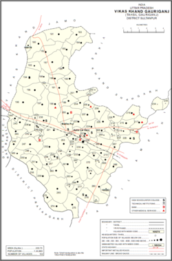 Map showing Barna Tikar (#221) in Gauriganj CD block | |
 Barna Tikar Location in Uttar Pradesh, India | |
| Coordinates: 26°12′40″N 81°39′42″E / 26.211075°N 81.661782°E[1] | |
| Country | |
| State | Uttar Pradesh |
| Division | Faizabad division |
| District | Amethi |
| Area [2] | |
| • Total | 4.475 km2 (1.728 sq mi) |
| Population (2011)[2] | |
| • Total | 2,927 |
| • Density | 650/km2 (1,700/sq mi) |
| Languages | |
| • Official | Hindi, Urdu |
| Time zone | UTC+5:30 (IST) |
Barna Tikar is a village in Gauriganj block of Amethi district, Uttar Pradesh, India.[2] As of 2011, it has a population of 2,927 people, in 531 households.[2] It has one primary school and no healthcare facilities and hosts both a permanent market and a weekly haat.[2] It belongs to the nyaya panchayat of Katra Lalganj.[3]
- ^ "Geonames Search". Do a radial search using these coordinates here.
- ^ a b c d e "Census of India 2011: Uttar Pradesh District Census Handbook - Sultanpur, Part A (Village and Town Directory)" (PDF). Census 2011 India. pp. 181–98. Retrieved 17 December 2021.
- ^ Cite error: The named reference
Census 1991was invoked but never defined (see the help page).