 Global Information
Baramulla information
Baramulla
Varmul | |
|---|---|
City | |
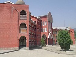 Baramulla School in Baramulla, Jammu & Kashmir | |
 Interactive map of Baramulla | |
![Baramulla lies in the Kashmir division (neon blue) of the Indian-administered Jammu and Kashmir (shaded tan) in the disputed Kashmir region.[1]](http://upload.wikimedia.org/wikipedia/commons/thumb/2/2f/Kashmir_region._LOC_2003626427_-_showing_Kashmir_division_administered_by_India_in_neon_blue.jpg/250px-Kashmir_region._LOC_2003626427_-_showing_Kashmir_division_administered_by_India_in_neon_blue.jpg) Baramulla lies in the Kashmir division (neon blue) of the Indian-administered Jammu and Kashmir (shaded tan) in the disputed Kashmir region.[1] | |
| Coordinates: 34°11′53″N 74°21′50″E / 34.198°N 74.364°E | |
| Administering country | India |
| Union Territory | Jammu & Kashmir |
| Division | Kashmir |
| District | Baramulla |
| Government | |
| • Type | Municipal Council |
| • Body | Municipal council Baramulla |
| Area [2][3] | |
| • Total | 23.98 km2 (9.26 sq mi) |
| Population (2011)[2][3] | |
| • Total | 71,434 |
| • Density | 3,000/km2 (7,700/sq mi) |
| Demonym(s) | Varmuliuk, Baramulluk |
| Languages [4][5] | |
| • Official | Kashmiri, Urdu, English |
| Demographics [3] | |
| • Literacy | 79.6% |
| • Sex ratio | 846.9 ♀/ 1000 ♂ |
| Time zone | UTC+5:30 (IST) |
| PIN | 193101 (New City), 193102 (Old City), 193103 |
| Telephone code | 01952 |
| Vehicle registration | JK-05 |
| Website | baramulla |
Baramulla (Urdu pronunciation: [baːɾaːmuːlaː]), also known as Varmul[6] (Kashmiri pronunciation: [warmul]) in Kashmiri, is a city and municipality of the Baramulla district of the Indian-administered Jammu and Kashmir in the disputed Kashmir region.[1] It is also the administrative headquarters of the Baramulla district, located on the banks of the River Jhelum downstream from Srinagar, the summer capital of Jammu and Kashmir. The town is known as gateway of Kashmir, serving as the major distribution centre for goods arriving in Kashmir valley through the Jhelum valley cart road.
The town was earlier known as Vārāhamūla. The name is derived from two Sanskrit words, Vārāha (meaning wild boar) and Mūla (meaning root/origin). The town was a major urban settlement and trade centre, before suffering extensive damage during the 1947 Pakistani tribal invasion of Kashmir. Currently, Baramulla is a major centre of business and education in Northern Kashmir.
- ^ a b The application of the term "administered" to the various regions of Kashmir and a mention of the Kashmir dispute is supported by the tertiary sources (a) through (d), reflecting due weight in the coverage. Although "controlled" and "held" are also applied neutrally to the names of the disputants or to the regions administered by them, as evidenced in sources (f) through (h) below, "held" is also considered politicized usage, as is the term "occupied," (see (i) below).
(a) Kashmir, region Indian subcontinent, Encyclopaedia Britannica, retrieved 15 August 2019 (subscription required) Quote: "Kashmir, region of the northwestern Indian subcontinent ... has been the subject of dispute between India and Pakistan since the partition of the Indian subcontinent in 1947. The northern and western portions are administered by Pakistan and comprise three areas: Azad Kashmir, Gilgit, and Baltistan, the last two being part of a territory called the Northern Areas. Administered by India are the southern and southeastern portions, which constitute the state of Jammu and Kashmir but are slated to be split into two union territories.";
(b) Pletcher, Kenneth, Aksai Chin, Plateau Region, Asia, Encyclopaedia Britannica, retrieved 16 August 2019 (subscription required) Quote: "Aksai Chin, Chinese (Pinyin) Aksayqin, portion of the Kashmir region, at the northernmost extent of the Indian subcontinent in south-central Asia. It constitutes nearly all the territory of the Chinese-administered sector of Kashmir that is claimed by India to be part of the Ladakh area of Jammu and Kashmir state.";
(c) "Kashmir", Encyclopedia Americana, Scholastic Library Publishing, 2006, p. 328, ISBN 978-0-7172-0139-6 C. E Bosworth, University of Manchester Quote: "KASHMIR, kash'mer, the northernmost region of the Indian subcontinent, administered partlv by India, partly by Pakistan, and partly by China. The region has been the subject of a bitter dispute between India and Pakistan since they became independent in 1947";
(d) Osmańczyk, Edmund Jan (2003), Encyclopedia of the United Nations and International Agreements: G to M, Taylor & Francis, pp. 1191–, ISBN 978-0-415-93922-5 Quote: "Jammu and Kashmir: Territory in northwestern India, subject to a dispute betw een India and Pakistan. It has borders with Pakistan and China."
(e) Talbot, Ian (2016), A History of Modern South Asia: Politics, States, Diasporas, Yale University Press, pp. 28–29, ISBN 978-0-300-19694-8 Quote: "We move from a disputed international border to a dotted line on the map that represents a military border not recognized in international law. The line of control separates the Indian and Pakistani administered areas of the former Princely State of Jammu and Kashmir.";
(f) Kashmir, region Indian subcontinent, Encyclopaedia Britannica, retrieved 15 August 2019 (subscription required) Quote: "... China became active in the eastern area of Kashmir in the 1950s and has controlled the northeastern part of Ladakh (the easternmost portion of the region) since 1962.";
(g) Bose, Sumantra (2009), Kashmir: Roots of Conflict, Paths to Peace, Harvard University Press, pp. 294, 291, 293, ISBN 978-0-674-02855-5 Quote: "J&K: Jammu and Kashmir. The former princely state that is the subject of the Kashmir dispute. Besides IJK (Indian-controlled Jammu and Kashmir. The larger and more populous part of the former princely state. It has a population of slightly over 10 million, and comprises three regions: Kashmir Valley, Jammu, and Ladakh.) and AJK ('Azad" (Free) Jammu and Kashmir. The more populous part of Pakistani-controlled J&K, with a population of approximately 2.5 million. AJK has six districts: Muzaffarabad, Mirpur, Bagh, Kodi, Rawalakot, and Poonch. Its capital is the town of Muzaffarabad. AJK has its own institutions, but its political life is heavily controlled by Pakistani authorities, especially the military), it includes the sparsely populated "Northern Areas" of Gilgit and Baltistan, remote mountainous regions which are directly administered, unlike AJK, by the Pakistani central authorities, and some high-altitude uninhabitable tracts under Chinese control."
(h) Fisher, Michael H. (2018), An Environmental History of India: From Earliest Times to the Twenty-First Century, Cambridge University Press, p. 166, ISBN 978-1-107-11162-2 Quote: "Kashmir’s identity remains hotly disputed with a UN-supervised “Line of Control” still separating Pakistani-held Azad (“Free”) Kashmir from Indian-held Kashmir.";
(i) Snedden, Christopher (2015), Understanding Kashmir and Kashmiris, Oxford University Press, p. 10, ISBN 978-1-84904-621-3 Quote:"Some politicised terms also are used to describe parts of J&K. These terms include the words 'occupied' and 'held'." - ^ a b A-4 Towns And Urban Agglomerations Classified By Population Size Class In 2011 With Variation Since 1901. Office of the Registrar General & Census Commissioner, Ministry of Home Affairs, Government of India (Report).
Class - II Population of 50,000 and 99,999 (Report). - ^ a b c District Census Handbook Baramulla, Part B (PDF). Census of India 2011 (Report). 16 June 2014. pp. 28–29. Retrieved 9 February 2021.
- ^ "The Jammu and Kashmir Official Languages Act, 2020" (PDF). The Gazette of India. 27 September 2020. Retrieved 27 September 2020.
- ^ "Parliament passes JK Official Languages Bill, 2020". Rising Kashmir. 23 September 2020. Archived from the original on 24 September 2020. Retrieved 23 September 2020.
- ^ Kashir Encyclopedia (in Kashmiri). Vol. 2. Jammu and Kashmir Academy of Arts Culture and Languages. 1989. p. 207.