Tutoh River, Temala River, Pelutan River, Patah River, Akah River, Buang River, Selaan River, Serungo River
• right
Arang River, Tinjar River, Julan River, Silat River, Moh River
The Baram River seen from the ASEAN Bridge
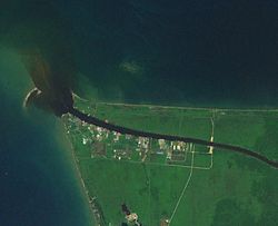
The Baram River (Malay: Sungai Baram) is a river in Sarawak on the island of Borneo. The river originates in the Kelabit Highlands, a watershed demarcated by the Iran Mountains of East Kalimantan, which form a natural border with Sarawak. The river flows westwards through tropical rainforest to the South China Sea.[3][4] The Baram River terminates in a delta, which is subdivided into two units: East Barma Delta of Middle-Late Miocene age and West Baram Delta of Late Miocene-Quaternary age.[5] The western unit is composed of mudstones enriched in organic components (total organic carbon content is more than 1.0 wt.%) which constitute substantial oil and gas reserves.[6]
The Baram river basin, an area of some 10,000 square miles (30,000 km2), has been part of Sarawak since it was ceded to the White Rajah of Sarawak by the then sultan of Brunei in 1882, for a perpetual annual payment of 6,000 dollars.[7]
The river is crossed not far from its mouth by the Miri-Baram Highway, Federal Route 22, on the Batang Baram Bridge opened in 2003. Some 100 km upstream lies the town of Marudi.[8]
^Ministry of Natural Reserves and Environment, Malaysia: National Water Resources Study, Vol. 29 - Sarawak[permanent dead link] (PDF; 72,3 MB) page 74
^Prabakaran, Krishnamurthy (2017). "Environmental Geochemistry of the Lower Baram River, Borneo" (PDF).[permanent dead link]
^Reed L. Wadley (2005). Histories of the Borneo Environment. KITLV Press. ISBN 90-6718-254-0.
^Louisiana State University
^Hutchison, Charles (2005). Geology of North-West Borneo: Sarawak, Brunei and Sabah. Amsterdam: Elsevier. ISBN 978-0-444-51998-6.
^Togunwa, Olayinka; Abdullah, Wan (2017-08-10). "Geochemical characterization of Neogene sediments from onshore West Baram Delta Province, Sarawak: paleoenvironment, source input and thermal maturity". Open Geosciences. 9 (1): 302–313. doi:10.1515/geo-2017-0025. ISSN 2391-5447.
^The Pagan Tribes of Borneo, retrieved 22-05-2007 Archived September 28, 2007, at the Wayback Machine
^"处处垃圾 影响环境 美里河污染严重 (Garbage everywhere Miri River environmental pollution)". Xinhua Daily (Shihua News) (in Chinese). 15 June 2014. Archived from the original on 16 June 2014. Retrieved 14 July 2017.
The BaramRiver (Malay: Sungai Baram) is a river in Sarawak on the island of Borneo. The river originates in the Kelabit Highlands, a watershed demarcated...
District, and is located on the banks of BaramRiver, about 100 kilometres (62 mi) upstream from the river mouth. Marudi was the administrative centre...
Malaysia Baram (federal constituency), represented in the Dewan Rakyat, Malaysia BaramRiver, a river in Malaysia Baram, a name for the Sacred fig Baram language...
Ulu Baram is a remote area of Sarawak in Malaysia. It is an encased alluvial plain, created in part by the BaramRiver. The forest is certified for logging...
(409 mi) Mendawai River 616 km (383 mi) Kayan River 576 km (358 mi) Rajang River 565 km (351 mi) Kinabatangan River 560 km (350 mi) BaramRiver 400 km (250 mi)...
candung) is a traditional chopper used by the Dayak people (Ibanese) of the BaramRiver in Borneo. The parang candung is also the primary weapon of Sari Panji...
Baram branch. It is spoken by some 2,420 Narom people in Sarawak, Malaysia, and particularly in the Miri Division and the area south of BaramRiver mouth...
northern interiors of Sarawak midway on the BaramRiver, the upper Rejang River and the lower Tubau River, and were traditionally headhunters. They are...
500. The name of the town is taken from a nearby river named "Lamah" that joins into the BaramRiver. The word "Long" is a Kayan word that means "estuary"...
The Baram Dam, also known as Baram 1 Dam and Baram Hydro-electric Dam Project (Malay: Empangan Baram) is a proposed gravity dam on the BaramRiver in Sarawak...
563 km (350 mi) including its tributary, Balleh River. To the north, the Baram, Limbang and Trusan Rivers drain into the Brunei Bay. Sarawak can be divided...
Slipways have their major shipyards set up in Miri - Kuala Baram industrial area along the Baramriver. First large-scale oil palm plantation in Sarawak began...
The Batang Baram Bridge or ASEAN Bridge is the longest bridge in Miri Division, Sarawak, Malaysia. The bridge is located along Miri-Baram Highway (Federal...
streams of the river with one to four metres in width, which converge into Dappur river, one of the main tributaries of the upper Baramriver. Some research...
help by sending a boat with the traditional Red Feather of War up the BaramRiver. Tom Harrisson, the Curator of the Sarawak Museum in Kuching and leader...
river between modern day Kalimantan and Sarawak. The territorial expansion of the Kayans caused the Mirieks to migrate northwards into areas of Baram...
wife visited BaramRiver but unlike the Sultan, they were happily welcomed by locals in 1872. Local Kayans near the mouth of the river were fined for...
river in Sarawak, after the Rajang River and BaramRiver. Notable settlements Notable settlements along the Lupar River, arranged from the mouth to upriver...
Lemeting or Meting. The latter was originally native to Tinjar River, a tributary of the BaramRiver in Sarawak, Malaysia; they later migrated to the area of...
through the Mulu Airport; or by boat from Marudi through the Tutoh and BaramRiver. There is no road access. Proposed extension of the park to Gunung Buda...
Tutong people might have originated from Lower Baram (Baram Hilir), a region near the mouth of the BaramRiver in Sarawak, Malaysia. This is based on the...
the state capital Kuching. The village is located in the Ulu Baram area on the BaramRiver between Long Selaan (upstream) and Long Bela'ong (downstream)...
state capital Kuching, in the upper reaches of the BaramRiver. The village is located on the BaramRiver between Long Palai (upstream) and Long Julan (downstream)...
Warlu River (33 km) Kawang Kawang River (21 km) Tiram River, Sabah Tuaran River (80 km) Ulu Tungku River Umas Umas River Balingian RiverBaramRiver Bayan...
Sarawak. This village consists of a single longhouse that located near BaramRiver and the population is 100 as of 1990 that consists of Kayan people. As...
Pulchrana baramica, the BaramRiver frog, brown marsh frog, or masked rough-sided frog, is a species of "true frog", family Ranidae. It is found in the...
34 ( July 1900): 39—48. [12] Hose, Charles. No. 3. "A Journey up the BaramRiver to Mount Dulit and the Highlands of Borneo". The Geographical Journal...
the state capital Kuching. The village is located in the Ulu Baram area on the BaramRiver between Long Semiyang (upstream) and Long Moh (downstream)....
east-north-east of the state capital Kuching. Long Palai is located on the BaramRiver in the Ulu Baram region of the interior of Sarawak, upstream from Long Anap. The...
 Global Information