For other articles with the same name, see Bannu (disambiguation).
Division in Khyber Pakhtunkhwa, Pakistan
Bannu Division
بنوں ڈویژن بنو څانګه
Division
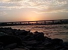
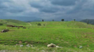
Images, from top down, left to right: The city of Bannu; A village in Lakki Marwat District; The Kurram River at Bannu; A scene in North Waziristan; Another scene in North Waziristan
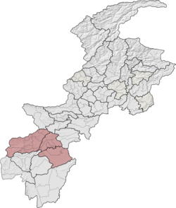
Bannu Division is one of seven divisions in Pakistan's Khyber Pakhtunkhwa province. It consists of three districts: Bannu, Lakki Marwat, and North Waziristan.[2][6] According to the 2017 Pakistani Census, the division had a population of 2,656,801,[2] making it the least populous division in the province, but it spans 9,975 km2 (3,851 sq mi) of area,[1] and this makes it the third-smallest division by area in the province. Lakki Marwat is the largest city of Bannu Division, with around 60,000 people, while the division's namesake and second-largest city is Bannu, with just under 50,000 people. The division borders Dera Ismail Khan Division to the south and west, Kohat Division to the north and east, and the province of Punjab, Pakistan to its east. CNIC code of Bannu Division is 11.
^ ab"1951 - 1998 POPULATION OF ADMINISTRATIVE UNITS (AS ON 1st MARCH 1998)" (PDF). 1951-98 Population of Administrative Units (As on 1st March, 1998).pdf. POPULATION CENSUS ORGANIZATION STATISTICS DIVISION GOVERNMENT OF PAKISTAN. January 2002. Archived (PDF) from the original on 23 August 2020. Retrieved 25 August 2020.
^ abc"PROVINCE WISE PROVISIONAL RESULTS OF CENSUS - 2017" (PDF). PAKISTAN TEHSIL WISE FOR WEB CENSUS_2017.pdf. Pakistan Bureau of Statistics. Archived from the original (PDF) on 16 June 2020. Retrieved 16 June 2020.
^"The Gazette of Pakistan Election Commission of Pakistan Notification" (PDF). National Assembly1.pdf. Election Commission of Pakistan. Archived from the original (PDF) on 21 June 2020. Retrieved 21 June 2020.
^"The Gazette of Pakistan Election Commission of Pakistan Notification" (PDF). Provincial KPK1.pdf. Election Commission of Pakistan. Archived from the original (PDF) on 21 June 2020. Retrieved 21 June 2020.
^"NOTIFICATION REGARDING RETURNED CANDIDATES OF PK-100 TO PK-114 (ERSTWHILE FATA)". ECP - Election Commission of Pakistan. Election Commission of Pakistan. 1 August 2019. Archived from the original on 21 July 2020. Retrieved 21 July 2020.
^"KP govt notifies new divisions following FATA merger". KP govt notifies new divisions following FATA merger | Pakistan Today. Pakistan Today. 20 July 2018. Archived from the original on 2 July 2020. Retrieved 2 July 2020.
BannuDivision is one of seven divisions in Pakistan's Khyber Pakhtunkhwa province. It consists of three districts: Bannu, Lakki Marwat, and North Waziristan...
in southern Khyber Pakhtunkhwa, Pakistan. It is the capital of BannuDivision. Bannu's residents are primarily members of the Banuchi tribe and speak...
Areas was split among two divisions: Dera Ismail Khan Division and Peshawar Division. Dera Ismail Khan Division covered Bannu District, Dera Ismail Khan...
Bannu District (Pashto: بنو ولسوالۍ, Urdu: ضلع بنوں) is a district in the BannuDivision of the Khyber Pakhtunkhwa province of Pakistan. Its status as...
is a list of all the tehsils of the Khyber Pakhtunkhwa. Baka Khel Tehsil Bannu Tehsil Domel Tehsil Kakki Tehsil Miryan Tehsil Wazir Tehsil Bettani Tehsil...
(Pashto: لکي مروت ولسوالۍ, Urdu: ضلع لکی مروت) is a district in the BannuDivision of the Khyber Pakhtunkhwa province of Pakistan. It was created as an...
Naseerabad Division was split from Sibi Division; Zhob Division was split from Quetta Division; BannuDivision was split from Dera Ismail Khan Division; Mardan...
Ismail Khan Division is 12. Dera Ismail Khan Division borders BannuDivision (also Khyber Pakhtunkhwa) in the north, Dera Ghazi Khan Division and Sargodha...
a population of 220,000. The division borders BannuDivision to the south and west, Peshawar Division to the north and east, the province of Punjab to...
Wazir Tehsil is an administrative subdivision (tehsil) of Bannu District, BannuDivision, Khyber Pakhtunkhwa Province, Pakistan. The total population,...
only 356 households. This makes it the least populous urban area in BannuDivision, but it is also the only urbanized area in the entire region of North...
Bannu Tehsil is an administrative subdivision (tehsil) of Bannu District, BannuDivision, Khyber Pakhtunkhwa Province, Pakistan.The population is 958,504...
valley which is now the Tahsil of Bannu and Marwat, as 'Bannu territory'. Babur also stated that when he came to Bannu in 1505, the Niazis were settlers...
south. Miramshah is district headquarter of North Waziristan. The city of Bannu lies immediately to the east, while the largest town on the Afghan side...
there are 7 divisions, which are further divided into districts ranging from two to nine per division, depending upon area. Divisions are governed by...
original on 2 February 2014. Retrieved 27 January 2014. "About BISE Bannu". BISE BANNU. "BISE DIKhan". www.bisedik.edu.pk. Retrieved 11 July 2020. "Board...
Bannu Cantonment is a cantonment adjacent to Bannu in Khyber Pakhtunkhwa, Pakistan. It is the only cantonment in Bannu District or the BannuDivision...
Marwat District and the third-largest in BannuDivision. Lakki Marwat Bannu Lakki Marwat District BannuDivision Ghoriwala List of tehsils of Khyber Pakhtunkhwa...
subdivision (tehsil) of Bannu District, BannuDivision, Khyber Pakhtunkhwa Province, Pakistan. It is located about 15 km from Bannu on Bannu–Kohat road. Domel...
Gulzari is a village in Lakki Marwat District of Khyber Pakhtunkhwa. It is located at 32°36'48N 70°31'52E with an altitude of 360 metres (1184 feet). Location...
Kurram River and the Gomal River. It borders the Kurram Agency in the north, Bannu in the northeast, Tank in the east, Dera Ismail Khan in the southeast, Sherani...
main town in Domel tehsil of Bannu District in Khyber Pakhtunkhwa province of Pakistan. It is also union council of Bannu District in Khyber-Pakhtunkhwa...
 Global Information