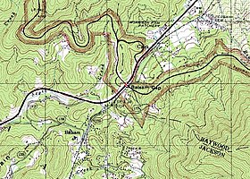
Balsam Gap (el. 3,316 ft (1,011 m)) is a mountain pass between the Plott Balsam Range to the northwest and the Great Balsam Mountains to the southeast on the county line dividing Haywood and Jackson counties in the U.S. state of North Carolina.
The gap allows both the Great Smoky Mountains Expressway and the former Murphy Branch of the Southern Railway, now owned by Blue Ridge Southern Railroad,[3] to cross between the two counties running east–west. The Blue Ridge Parkway also runs through the gap in a north–south direction crossing both the expressway and railway branch.
The gap is named for the Great Balsam Mountains in which it lies. The small, unincorporated communities of Balsam in Jackson County and Saunook in Haywood County are also located close by.
^General Highway Map, Jackson County, North Carolina(PDF) (Map). North Carolina Department of Transportation. 2014. Retrieved July 18, 2014.[permanent dead link]
^"Balsam Gap". Geographic Names Information System. United States Geological Survey, United States Department of the Interior. Retrieved July 18, 2014.
^Kansas company buys railroad lines in Jackson County, WNC, The Sylva Herald (retrieved 14 September 2015)
BalsamGap (el. 3,316 ft (1,011 m)) is a mountain pass between the Plott Balsam Range to the northwest and the Great Balsam Mountains to the southeast...
The Plott Balsams are a mountain range in western North Carolina in the southeastern United States. The Plott Balsams are part of the Blue Ridge Mountain...
point east of the Mississippi River. 359.8 Walker Knob, formerly known as BalsamGap, is located where the Black Mountains and the Great Craggy Mountains meet...
The Great Balsam Mountains, or Balsam Mountains, are in the mountain region of western North Carolina, United States. The Great Balsams are a subrange...
county line at BalsamGap, where it also connects to the Blue Ridge Parkway. The eastern freeway segment begins at the US 23 Business (Balsam Road) interchange...
Gap – Vermont Ashby Gap – Virginia BalsamGap – North Carolina Brock Gap – Alabama Brocks Gap – Virginia Buck Creek Gap – North Carolina Buford's Gap...
Canton Clyde Waynesville Hazelwood Saunook BalsamGap (junction of US 74 and the Blue Ridge Parkway) Balsam Willits-Ochre Hill Addie Beta Sylva Dillsboro...
Soco Gap (el. 4,340 ft (1,320 m)) is a mountain pass between the Plott Balsams to the south and the Great Balsam Mountains to the north. The gap is the...
GPX (secondary coordinates) The following is a list of mountain passes and gaps in the U.S. state of North Carolina. United States portal Geography portal...
needed] Examples of plant resins include amber, Balm of Gilead, balsam, Canada balsam, copal from trees of Protium copal and Hymenaea courbaril, dammar...
Tarheel High Points Tennessee 1,000' Prominence Black Balsam Knob is precisely 31.48 miles from Brown Gap at 35°46′23″N 82°59′38″W / 35.77306°N 82.99389°W...
Appalachian Mountains, including parts of the Blue Ridge Mountains and Great Balsam Mountains. Elevations reach over 6,000 feet (1,800 m) and include some of...
Richland-BalsamGap at 6,053 feet (1,845 m). 242.0 389.5 Mountain Cherohala Skyway Traversing along NC 143, from the Tennessee state line to Santeetlah Gap, in...
Huntington Gap Wildlife Management Area is a wildlife management area in the U.S. state of Vermont. It consists of 1,602 acres (648 ha) in the towns of...
Loeb Trail View from the southern sub-peak of Black Balsam Knob Cedar Rock from the trail Flower Gap View from Tennent Mountain https://www.fs.usda.gov...
upland and bog habitats, balsam fir, as well as black spruce and tamarack, are more characteristic of the latter. However, balsam fir also does well in soils...
and Widmark. The cast also features Eric Portman, James MacArthur, Martin Balsam, and Wally Cox, as well as early appearances by Donald Sutherland and Ed...
imitator salamander is found only in the Smokies and the nearby Plott Balsams and Great Balsam Mountains. Two other species—the southern gray-cheeked salamander...
discernible. The old Hyatt/Balsam junction is located just over 10 miles (16 km) from the Balsam Mountain Trailhead at Pin Oak Gap (along Straight Fork Road)...
of allergic contact dermatitis include: nickel allergy, 14K or 18K gold, Balsam of Peru (Myroxylon pereirae), and chromium. In the Americas they include...
accommodate 14 people. Laurel Gap Shelter is one of the more remote shelters in the park. Situated in a beech forest swag between Balsam High Top and Big Cataloochee...
wind. The period of the waves is variable, typically about 60 years in balsam fir (Abies balsamea). One can view these from the Appalachian Trail as it...
stands on all sites. Other commonly associated overgrowth species include balsam fir (Abies balsamea), white spruce (Picea glauca), and quaking aspen (Populus...
 Global Information