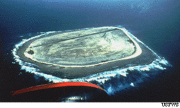
Baker Island, formerly known as New Nantucket,[1] is an uninhabited atoll just north of the Equator in the central Pacific Ocean about 3,090 km (1,920 mi) southwest of Honolulu. The island lies almost halfway between Hawaii and Australia. Its nearest neighbor is Howland Island, 42 mi (68 km) to the north-northwest; both have been claimed as territories of the United States since 1857, though the United Kingdom considered them part of the British Empire between 1897 and 1936.
The island covers 2.1 km2 (0.81 sq mi),[2] with 4.8 km (3.0 mi) of coastline.[2] The climate is equatorial, with 80°F Temperature, scant rainfall, constant wind, and strong sunshine. The terrain is low-lying and sandy: a coral island surrounded by a narrow fringing reef with a depressed central area devoid of a lagoon with its highest point being 8 m (26 ft) above sea level.[2]
The island now forms the Baker Island National Wildlife Refuge and is an unincorporated and unorganized territory of the U.S. which vouches for its defense. It is visited annually by the U.S. Fish and Wildlife Service. For statistical purposes, Baker is grouped with the United States Minor Outlying Islands. Baker Island and Howland Island are also the last pieces of land that experience the New Year (furthest behind time zone – UTC−12:00).
Baker Island is one of the most remote U.S. equatorial possessions.[3]
^Rauzon, Mark J. (2016). Isles of Amnesia: The History, Geography, and Restoration of America's Forgotten Pacific Islands. University of Hawai'i Press, Latitude 20. Page 110. ISBN 9780824846794.
^ abc"United States Pacific Island Wildlife Refuges". The World Factbook (2024 ed.). Central Intelligence Agency. Retrieved April 25, 2014. (Archived 2014 edition.)
^Rauzon, Mark J. (2016). Isles of Amnesia: The History, Geography, and Restoration of America's Forgotten Pacific Islands. University of Hawai'i Press, Latitude 20. Pages 38 and 104. ISBN 9780824846794.
BakerIsland, formerly known as New Nantucket, is an uninhabited atoll just north of the Equator in the central Pacific Ocean about 3,090 km (1,920 mi)...
Howland Island and BakerIsland are two uninhabited U.S. atolls in the Equatorial Pacific that are located close to one another. Both islands are wildlife...
outlying islands and groups of islands consist of eight United States insular areas in the Pacific Ocean (BakerIsland, Howland Island, Jarvis Island, Johnston...
the Gilberts Island group (which itself was sometimes known as the Kingsmill island group). Geographically, BakerIsland and Howland Island, two unincorporated...
The island lies almost halfway between Hawaii and Australia and is an unorganized, unincorporated territory of the United States. Together with Baker Island...
largest of three U.S. equatorial possessions, which include BakerIsland and Howland Island. It was claimed by the US in the 19th century and mined for...
The Line Islands Howland Island, BakerIsland, Jarvis Island, Malden Island and Starbuck Island Tuvalu, Tokelau and the Northern Cook Islands (Pukapuka...
BakersIsland is a small, private residential island in Massachusetts Bay, in Salem, Massachusetts. It is located southeast of Great Misery Island & Little...
Minor Outlying Islands comprises BakerIsland, Howland Island, Jarvis Island, Johnston Atoll, Kingman Reef, Midway Atoll, Navassa Island, Palmyra Atoll...
Interior: BakerIsland, Howland Island, Jarvis Island, Johnston Atoll, Kingman Reef, the Midway Islands, Navassa Island, Palmyra Atoll, and Wake Island. Moore...
Line Islands is 26 hours ahead of some other islands in Oceania, such as BakerIsland, which uses UTC−12:00. Copra and pet fish are the islands' main...
Zulu time (UTC±00:00) when on these islands. BakerIsland and Howland Island are in UTC−12:00, while Wake Island is in UTC+12:00. Because they exist on...
an antibiotic Football Queensland, an Australian sports organisation BakerIsland (FIPS PUB 10-4 territory code FQ), an unincorporated and unorganized...
Agency. Retrieved July 9, 2013. "Virgin Islands". The World Factbook. Retrieved July 9, 2013. "BakerIsland". Office of Insular Affairs. Archived from...
City Dallas San Francisco UTC−12:00 (BakerIsland, Howland Island) Samoa Time Zone (American Samoa, Jarvis Island, Kingman Reef, Midway Atoll, Palmyra...
Buariki Island), and the United States (south of BakerIsland). Despite its name, no part of Equatorial Guinea lies on the Equator. However, its island of...
Virgin Islands, Anguilla to the south east and Samoa, Niue to the south west. The unincorporated territories of Guam, Puerto Rico, U.S. Virgin Islands and...
As of 2022[update], the islands still claimed by the United States under the Act are: BakerIsland Howland Island Jarvis Island Johnston Atoll Kingman...
90th meridian west and the Equator, among the Galápagos Islands. The nearest land is Genovesa Island at 0°19′N 89°57′W / 0.317°N 89.950°W / 0.317; -89...
BakerIsland Light is a lighthouse on BakerIsland, Maine, which is part of Acadia National Park. The light station was established in 1828 as a guide...
western Aleutian Islands, UTC−10, which means that locations to the south-southeast (such as the uninhabited BakerIsland and Howland Island in UTC−12 and...
Stevenson Island Agrigan As-Gadao Cabras Island Cocos Island Fofos Guam BakerIsland Howland Island Jarvis Island Johnston Atoll Akau (North) Island Hikina...
 Global Information