A ridge in the eastern Caribbean Sea west of the Lesser Antilles Volcanic Arc
14°00′N63°30′W / 14°N 63.5°W / 14; -63.5
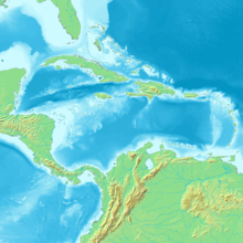
Topographic/bathymetric map of the Caribbean, with the Aves Ridge to the west of the Lesser Antilles
The Aves Ridge is a ridge in the eastern Caribbean Sea. It runs in a north-south direction, approximately 250 km west of the Lesser Antilles Volcanic Arc. It is mostly under water, but it reaches the surface in the north as Aves Island and in the south as La Blanquilla Island.[1][2] Most geologists believe that the Aves Ridge originated as a volcanic arc which is now extinct, though its width poses a problem;[3] the date of its origin is generally placed in the Cretaceous.[4][5]
^"Isla Blanquilla, Venezuela: Image of the Day". NASA. 26 November 2007. Archived from the original on 25 April 2009.
^James, Keith L. "The Caribbean Ocean Plateau – an overview, and a different understanding" (PDF). pp. 2, 4. Archived (PDF) from the original on 3 October 2008.
^Westbrook, G.K; Biju-Duval, B.; Mascle, A. (September 20, 1983). "Geophysics and the Structure of the Lesser Antilles Forearc" (PDF). Deep Sea Drilling Project. Retrieved 22 September 2017.
^James, Keith H. (2007). "The Caribbean Ocean Plateau – an overview, and a different understanding" (PDF). MantlePlumes.org. Retrieved 22 September 2017.
^Bally, Albert W.; Palmer, Allison R., eds. (1989). Geology of North America—An Overview. Boulder, Colorado: Geological Society of America. p. 314. ISBN 9780813754451.
the surface in the north as Aves Island and in the south as La Blanquilla Island. Most geologists believe that the AvesRidge originated as a volcanic arc...
Isla de Aves ([ˈisla ðe ˈaβes]; Spanish for "Island of Birds" or "Birds Island"), or Aves Island, is a Federal Dependency of Venezuela. It has been the...
bordered by the Lesser Antilles in the north, south, and east, and the AvesRidge in the west. The Grenada Basin has no active spreading center. The basin...
South America from North America during the Paleocene, possibly via the AvesRidge. Northern Hemisphere metatherians, which were of low morphological and...
has been associated with the GAARlandia (Greater Aves Antilles Ridge) hypothesis, where the AvesRidge is suggested to have formed a land bridge during...
which is used for jewelry and other crafts. The island is formed by the AvesRidge, a seafloor feature which protrudes above water to the north, forming...
0.CO;2. Alfonso-Sosa, Edwin (September 2012). "Estimated Speed of AvesRidge Solitons Packets by Analysis of Sequential Images from the Moderate Resolution...
cabin on Ridge Avenue and bought a tract of land in the unincorporated area now bounded by Touhy Ave., Western Ave., RidgeAve., and Morse Ave. from the...
A short-lived (~1 Ma) landmass named "GAARlandia" (Greater Antilles + AvesRidge land) connected northwestern South America with three of the Greater Antilles...
September 23, 2021. ISEPTAPHILLY Blog. "Route of the Week – Broad–Ridge Spur". SEPTA. "RidgeAve. Subway to Run Tomorrow". The Philadelphia Inquirer. December...
way to the Caribbean coast of South America. The Greater Antilles and AvesRidge land bridge, GAARlandia preceded the formation of the Isthmus of Panama...
Dinosaur Ridge is a segment of the Dakota Hogback in the Morrison Fossil Area National Natural Landmark located in Jefferson County, Colorado, near the...
of the United States Location Roughly bounded by Fulton St., Heilig Ave., RidgeAve., and Boyden St., Salisbury, North Carolina Coordinates 35°39′40″N...
March 2021. "Observação de aves". visitportugal.com. Archived from the original on 14 April 2021. Retrieved 20 March 2021. "Aves de Portugal". avesdeportugal...
birds, too, are a clade, universally ascribed to the formal taxon Aves. Mammalia and Aves are, in fact, subclades within the grand clade of the Amniota....
driven from Missouri early in the war as a result of the Battle of Pea Ridge. Extensive guerrilla warfare characterized the trans-Mississippi region...
The Fisher Ridge Cave System is a cave system located in Hart County, Kentucky, United States, near Mammoth Cave National Park. As of November 2019 it...
 Global Information