 Global Information
Aurlandsfjord information
| Aurlandsfjord | |
|---|---|
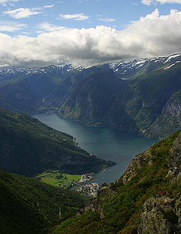 View of the fjord | |
 Aurlandsfjord Location of the village  Aurlandsfjord Aurlandsfjord (Norway) | |
| Location | Vestland county, Norway |
| Coordinates | 60°54′56″N 7°10′13″E / 60.9155°N 7.1702°E |
| Primary inflows | Nærøyfjorden |
| Primary outflows | Sognefjorden |
| Basin countries | Norway |
| Max. length | 29 kilometres (18 mi) |
| Average depth | 962 metres (3,156 ft) |
| Settlements | Aurlandsvangen, Flåm |
Aurlandsfjord (Norwegian: Aurlandsfjorden, Urban East Norwegian: [ˈæ̂ʉrlɑnsˌfjuːɳ]) is a fjord in Vestland county, Norway. The fjord flows through the municipalities of Aurland, Vik, and Lærdal. The 29-kilometre (18 mi) long fjord is a branch off of the main Sognefjorden, Norway's longest fjord. The fjord is deep and narrow, reaching a depth of about 962 metres (3,156 ft) below sea level, and its width is generally less than 2 kilometres (1.2 mi) wide. About 11 kilometers (6.8 mi) south of the mouth of the fjord, the Nærøyfjord branches off from it to the west. The village of Flåm sits at the innermost part of the Aurlandsfjord; other villages along the fjord are Aurlandsvangen and Undredal. Most of the fjord is surrounded by up to 1,800-metre (5,900 ft) tall, steep mountains with little habitation along the fjord except for in a few small valleys.[1]
Tremors of the 2011 Tōhoku earthquake and tsunami arrived 12 minutes later in Aurlandsfjord, causing 1.5 meter waves for a few hours.[2][3][4]
Large parts of the fjord are included in the Nærøyfjord section of the West Norwegian Fjords UNESCO World Heritage Site.
- ^ Store norske leksikon. "Aurlandsfjorden" (in Norwegian). Retrieved 2014-02-28.
- ^ Union, American Geophysical (August 2013). "An earthquake in Japan caused large waves in Norwegian fjords". phys.org. Retrieved 2022-04-16.
- ^ Oskin, Becky (18 August 2013). "Norway's weird waves traced to Japan quake". NBC News.
- ^ Bondevik, Stein; Gjevik, Bjørn; Sørensen, Mathilde B. (16 July 2013). "Norwegian seiches from the giant 2011 Tohoku earthquake: NORWEGIAN SEICHES". Geophysical Research Letters. 40 (13): 3374–3378. doi:10.1002/grl.50639.