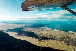
Athabasca Sand Dunes Provincial Park was created to protect the Athabasca sand dunes, a unique boreal shield ecosystem located in the far-northwest part of the Northern Saskatchewan Administration District.[1] The Athabasca sand dunes are one of the most northerly active sand dune formations on Earth.[2]
It first came to attention that it should be a protected area in 1969,[1] finally becoming the Athabasca Sand Dunes Provincial Wilderness Park on August 24, 1992.
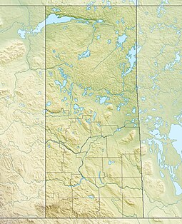
The park extends for 100 kilometres (62 mi) along the southern edge of Lake Athabasca[3] and lies within the Athabasca Basin of the Canadian Shield. The sand dunes are 400 to 1,500 metres long, with a maximum height of approximately 30 metres.[2] The park is accessible by float plane or boat only.[4]
The William River flows through the western section of the park, ending in a large river delta. The McFarlane River flows through the far eastern section of the park. The First Nations village of Fond du Lac is about 44 kilometres (27 mi), by air, from the park's eastern boundary.[5][6] The park goes around the Fond du Lac 231 Indian reserve, located on the McFarlane.
^ ab"Athabasca Sand Dunes". Canadian Parks and Wilderness Society. Archived from the original on November 29, 2011. Retrieved July 25, 2013.
^ abStewart, Iain (2006). "Athabasca Sand Dunes". Encyclopedia of Saskatchewan. Canadian Plains Research Centre, University of Regina. Retrieved November 10, 2011.
^"Unique Places to visit in Saskatchewan". To Do Canada. July 21, 2023. Retrieved March 30, 2024.
^"Saskatchewan 2011-2012 Provincial Parks Guide". Saskatchewan Ministry of Tourism, Parks, Culture and Sport. 2006: 43. Archived from the original (PDF) on October 17, 2012. Retrieved November 10, 2011. {{cite journal}}: Cite journal requires |journal= (help)
^Jones, Art (2006). "Saskatchewan's Athabasca Sand Dunes". Western Canadian Online Outdoors News. Ya'Gotta Communications & Marketing. Retrieved November 10, 2011.
^"Provincial Parks". The Encyclopedia of Saskatchewan. University of Regina. Archived from the original on September 20, 2022. Retrieved September 20, 2022.
and 29 Related for: Athabasca Sand Dunes Provincial Park information
planet Mars AthabascaSandDunesProvincialPark, a unique geophysical land feature in the boreal shield ecosystem Saskatchewan, Canada Athabasca Basin, a...
away. The Lake AthabascaSandDunes, the largest active sanddunes in the world north of 58°, are adjacent to the southern shore. The dunes were designated...
Wilderness Park in eastern Manitoba and Lac la Ronge and AthabascaSandDunesProvincialPark in Saskatchewan. List of ecoregions in Canada (WWF) Wikimedia...
the complete list of national, provincial and regional parks in Saskatchewan. The AthabascaSandDunesProvincialPark is a unique geophysical land feature...
Turnor's willow, is a species of willow. It is endemic to the AthabascaSandDunesProvincialPark in Saskatchewan, Canada. It is listed as imperiled by NatureServe...
attractions include a purple sand beach, sanddunes, mature forests, crystal clear lake water, and several natural sand beaches. Highways 265 and 120...
layers and the Precambrian bedrock. The AthabascaSand Hills protected by The AthabascaSandDunesProvincialPark are unique feature of the Canadian Shield...
more parks were added by the end of the 1930s and Little Manitou ceased to be a provincialpark in 1956 and in 1962, it became a regional park. The list...
The Great Sand Hills are the second largest active dunes in Saskatchewan, after AthabascaSandDunes, and are part of Great Sandhills Ecological Reserve...
to the park's amenities. Attractions and activities at the park include campgrounds, picnicking, boating, swimming, and hiking through sanddunes. Two kilometres...
Wildland ProvincialPark in the southwest. Between the sanddunes are depressions containing numerous wetlands. The dominant vegetation on the sand is Jack...
The park is contained in the Upper Athabasca Land Use Framework. The park is managed through the Fort Assiniboine Sandhills Wildland ProvincialPark Management...
Lower Athabasca Regional Plan Land Use Framework in August 2012. Two smaller parks, La Butte Creek and Colin-Cornwall Lakes Wildland ProvincialParks, were...
The park is included in the Upper Athabasca Region Land Use Framework. The park is named for Winagami Lake which is adjacent to the park. The park is in...
Zone 0b. The Athabasca Basin provides a separate ecosystem. The AthabascaSand Hills protected by The AthabascaSandDunesProvincialPark are unique feature...
time. Provincial and territorial parks are administered and funded by their respective governments. However, Quebec has named its provincialparks “national...
is Alberta's largest sand island, It is located in Lake Athabasca in the part of the Fidler-Greywillow Wildland ProvincialPark. The Lucas Islands lie...
jamediasolutions.com (April 24, 2009). "Jasper Activities - Jasper National Park, Jasper Lake SandDunes". Archived from the original on April 26, 2014. Retrieved September...
44 national parks and park reserves in Canada's national park system (though one of only two in Saskatchewan itself). This national park is north of the...
Block" of the Cypress Hills spans the provincial boundary. Battle Creek runs through the central part of the park. Although the hills seem relatively low...
Buffalo Pound ProvincialPark is in southern Saskatchewan, Canada, about 30 kilometres (19 mi) north-east of Moose Jaw and 86 kilometres (53 mi) north-west...
was rebuilt by the government of Saskatchewan as a feature of a provincial historic park and can be visited today. It is about 65 kilometres (40 mi) north...
 Global Information