Global Information Lookup Global Information

Ashley River information


Ashley River
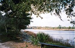
Ashley River, as seen from Brittlebank Park
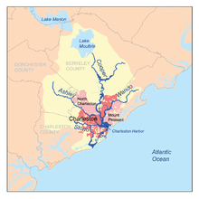
Map of the Charleston Harbor watershed showing Ashley River
Ashley River is located in South Carolina
Ashley River
Location of mouth
Location
CountryAshley River United States
StateAshley River South Carolina
CountyDorchester County
Charleston County
Physical characteristics
Mouth 
 • location
Charleston Harbor, Atlantic Ocean
 • coordinates
32°45′46″N 79°55′44″W / 32.76278°N 79.92889°W / 32.76278; -79.92889

The Ashley River is a blackwater and tidal river in South Carolina, rising from the Wassamassaw and Great Cypress Swamps in western Berkeley County. It consolidates its main channel about five miles west of Summerville, widening into a tidal estuary just south of Fort Dorchester. The river then flows for approximately 17 mi (27 km) along the historical banks of the City of North Charleston before reaching peninsular Charleston. The much wider Ashley joins the Cooper River off the Battery in Charleston to form Charleston Harbor before discharging into the Atlantic Ocean. As of 2012 the land around the Ashley River (or in Ashley Barony, as the original land grant was called) is mostly undeveloped.[1][2]

The river was named for Anthony Ashley Cooper, 1st Earl of Shaftesbury and chief Lord Proprietor of the Carolina Colony by explorer Robert Sandford.[3] In 1675 Cooper was granted 12,000 acres (4,900 ha) of land along the river after a permanent settlement was made at Albemarle Point in 1670. This settlement was the “first permanent European settlement” in South Carolina and today Albemarle Point is known as Charles Towne Landing. The settlement would be moved to its current peninsular location across the river ten years later and is well known as Charleston.

The land closest to the river was developed by plantation owners throughout the eighteenth century. During the Revolutionary War the British occupied the plantations from 1780 to 1782. The major crops grown along the Ashley River included rice, indigo, and cotton. After the Civil War much of the region began to be used predominantly for hunting and tourism.[4]

The Ashley River area contains 26 separate sites listed in the National Register of Historic Places with 22 mi (35 km) being designated a State Scenic River, extending from Sland's Bridge (US Highway 17-A) near Summerville to the Mark Clark expressway (I-526) bridge in Charleston.[5] Within this segment, a visitor can experience a blackwater swamp, the tides of the Atlantic, and much of the history of South Carolina. Some of the sites include Drayton Hall, Middleton Place, Magnolia Plantation, and the Colonial Dorchester State Historic Site. The River ranges from 6 to 8 feet in depth.

  1. ^ "South Carolina Department of Natural Resources - Ashley Scenic River". Archived from the original on April 19, 2012. Retrieved May 8, 2012.
  2. ^ U.S. Geological Survey Geographic Names Information System: Ashley River
  3. ^ Robert Sandford, “A Relation of a Voyage on the Coast of the Province of Carolina, 1666,” in Salley, AS, ed [1911], 1967, “Narratives of Early Carolina, 1650-1708, Vol. 4 of “Original Narratives of Early American History,” Edited by J. Franklin Jameson (New York: Barnes and Noble) p. 108, found in Lockhart, Matthew A. “Quitting More Than Port Royal: A Political Interpretation of the Siting and Development of Charles Town, South Carolina, 1660-1680”, Southeastern Geographer, Vol 43, N 2, Nov 2003, UNC Press
  4. ^ "The History of the Ashley River Corridor". Retrieved October 10, 2014.
  5. ^ "Ashley Scenic River". Retrieved May 28, 2021.

and 19 Related for: Ashley River information

Request time (Page generated in 0.8497 seconds.)

Ashley River

Last Update:

The Ashley River is a blackwater and tidal river in South Carolina, rising from the Wassamassaw and Great Cypress Swamps in western Berkeley County. It...

Word Count : 497

Ashley

Last Update:

Ashley, Missouri Ashley, North Dakota Ashley, Ohio Ashley, Pennsylvania Ashley, West Virginia Ashley, Wisconsin Ashley River, South Carolina "Ashley"...

Word Count : 316

West Ashley

Last Update:

derived from the fact that the land is west of the Ashley River. The first neighborhoods west of the Ashley were developed in the postwar period of the 1950s...

Word Count : 1630

Ashley Gorge

Last Update:

The Ashley Gorge is a river gorge of the Ashley River / Rakahuri in Canterbury, New Zealand. The river is bridged at the mouth of the gorge by the Inland...

Word Count : 480

Drayton Hall

Last Update:

house located on the Ashley River about 15 miles (24 km) northwest of Charleston, South Carolina, and directly across the Ashley River from North Charleston...

Word Count : 822

Ashley River Railroad

Last Update:

The Ashley River Railroad was a shortline railroad that served the South Carolina Lowcountry region in the late 19th century. The Ashley River Railroad...

Word Count : 326

Ashley Judd

Last Update:

Ashley Judd (born April 19, 1968) is an American actress. She grew up in a family of performing artists, the daughter of country music singer Naomi Judd...

Word Count : 3964

South Carolina Highway 61

Last Update:

have been rezoned commercial. Ashley River Road is the portion of SC 61 that travels through Charleston near the Ashley River from SC 171 to SC 165. It is...

Word Count : 1174

West Ashley Greenway

Last Update:

$18 million grant to build a pedestrian bridge across the Ashley River connecting West Ashley to downtown Charleston. The planned pedestrian bridge may...

Word Count : 261

Interstate 526

Last Update:

Sam Rittenberg Boulevard) in the West Ashley section of the city of Charleston, just north of the Stono River. The interchange includes a loop ramp from...

Word Count : 1440

The Citadel

Last Update:

Marion Square in downtown Charleston to a new campus on the banks of the Ashley River on the northwest side of the city. The Citadel has grown steadily from...

Word Count : 8336

The Notebook

Last Update:

Charleston, South Carolina, prior to filming. During two months, he rowed the Ashley River and made furniture. When James Garner was approached for the role of...

Word Count : 4658

Ashley Forest

Last Update:

Zealand's South Island. It is located north of the Ashley River / Rakahuri and northeast of the Okuku River. The forest was planted from 1939. It is managed...

Word Count : 449

Middleton Place

Last Update:

a plantation in Dorchester County, along the banks of the Ashley River west of the Ashley and about 15 miles (24 km) northwest of downtown Charleston...

Word Count : 2554

Stono Rebellion

Last Update:

held by the Cato (or Cater) family, who lived near the Ashley River and north of the Stono River. He led 20 other enslaved Kongolese, who may have been...

Word Count : 2536

McLeod Plantation

Last Update:

intersection of Folly and Maybank roads at Wappoo Creek, which flows into the Ashley River. The plantation is considered an important Gullah heritage site, preserved...

Word Count : 680

Kiawah people

Last Update:

Charleston, South Carolina. When English colonists arrived and settled on the Ashley River, the Kiawah were friendly. The Kiawah and the Etiwan tribe were the two...

Word Count : 731

Ashley River Historic District

Last Update:

Ashley River Historic District is a historic district located west of the Ashley in the South Carolina Lowcountry in Charleston, South Carolina, United...

Word Count : 371

Campus of The Citadel

Last Update:

in a Spanish Moorish style. The campus is bounded on the west by the Ashley River, to the north by the Wagener Terrace neighborhood, to the east by Hampton...

Word Count : 491

PDF Search Engine © AllGlobal.net