Route 43 at the Missouri state line Concurrent with OK-20
Section 2
Length
29.525 mi[2] (47.516 km)
South end
AR 21 at Boxley
North end
AR 7 in Harrison
Section 3
Length
1.788 mi[2] (2.878 km)
South end
US 65 in Harrison
North end
AR 7 in Harrison
Location
Country
United States
State
Arkansas
Counties
Benton, Boone, Newton, Delaware (OK)
Highway system
Arkansas Highway System
Interstate
US
State
Business
Spurs
Suffixed
Scenic
Heritage
← AR 42
→ AR 44
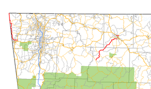
Highway 43 (AR 43, Ark. 43, and Hwy. 43) is a designation for three north–south state highways in Arkansas. One segment of 27.1 miles (43.6 km) runs from Highway 264 in Siloam Springs north into Delaware County, Oklahoma[3] along Oklahoma State Highway 20 (SH-20) to terminate at Missouri Route 43 (Route 43) at the Missouri/Oklahoma/Arkansas tri-point near Southwest City, Missouri.[4] A second segment of 20.0 miles (32.2 km) runs northeast from Highway 21 at Boxley to Highway 7 in Harrison.[5][6] The third segment runs 1.8 miles (2.9 km) north in Harrison from US Route 65 (US 65) to Highway 7 .[6]
^Arkansas State Highway Department (April 1, 1926). State of Arkansas Showing System of State Highways(TIF) (Map). 1:500,000. Little Rock: Arkansas State Highway Commission. Retrieved November 29, 2020 – via Arkansas GIS Office.
^ abcSystem Information and Research Division (2016). "Arkansas Road Log Database". Arkansas State Highway and Transportation Department. Archived from the original (MDB) on August 29, 2017. Retrieved November 29, 2020.
^Delaware County, Oklahoma(PDF) (Map). Oklahoma Department of Transportation. June 2004. Retrieved January 30, 2013.
^General Highway Map, Benton County, Arkansas(PDF) (Map). 1:62500. Cartography by Planning and Research Division. Arkansas State Highway and Transportation Department. August 20, 2012. Retrieved January 30, 2013.
^General Highway Map, Newton County, Arkansas(PDF) (Map). 1:62500. Cartography by Planning and Research Division. Arkansas State Highway and Transportation Department. September 16, 1996. Archived from the original (PDF) on September 29, 2011. Retrieved January 30, 2013.
^ abGeneral Highway Map, Boone County, Arkansas(PDF) (Map). 1:62500. Cartography by Planning and Research Division. Arkansas State Highway and Transportation Department. December 22, 2011. Retrieved January 30, 2013.
and 20 Related for: Arkansas Highway 43 information
Highway43 (AR 43, Ark. 43, and Hwy. 43) is a designation for three north–south state highways in Arkansas. One segment of 27.1 miles (43.6 km) runs from...
City), Arkansas, and Oklahoma where it continues down the Arkansas/Oklahoma state line as both ArkansasHighway43 and Oklahoma State Highway 20. North...
of state highways in the U.S. state of Arkansas. The state does not use a numbering convention. Generally, the two-digit odd numbered highways run north–south...
Interstate 530 (I-530) in Arkansas is a spur route of the Interstate highway system, traveling 46.65 miles (75.08 km) from Pine Bluff north-northwest to...
the original Arkansas state highways. The route begins at Highway43 in Maysville and runs east to Gravette. Highway 72 intersects Highway 59 in Gravette...
Highway 7 (AR 7, Ark. 7, Hwy. 7, and partially Scenic 7 Byway) is a north–south state highway that runs across the state of Arkansas. As Arkansas's longest...
Highway 1, which is common practice. ArkansasHighway 1 Business is a business route in DeWitt. It is 2.13 miles (3.43 km) in length. Major intersections...
Highway 102 (AR 102, Ark. 102, Hwy. 102) is an east–west state highway in Benton County, Arkansas. The highway connects two of western Benton County's...
Highway 16 (AR 16, Ark. 16, and Hwy. 16) is an east–west state highway in Arkansas. The route begins in Siloam Springs at US Highway 412 (US 412) and Highway 59...
Cherokee City east to ArkansasHighway 23 near Clifty. AR 12 begins at the Oklahoma state line at SH-116. The route runs east, crossing AR 43 before entering...
ArkansasHighway 59 is a north–south state highway in Northwest Arkansas. The route runs 93.24 miles (150.06 km) from ArkansasHighway 22 in Barling north...
Interstate 49 (I-49) is an Interstate Highway in the state of Arkansas. There are two main sections of the highway across different sides of the state....
ArkansasHighway 23 is a north–south state highway in north Arkansas. The route runs 129.88 miles (209.02 km) from US 71 near Elm Park north to the Missouri...
Highway 21 (AR 21, Ark. 21, and Hwy. 21) is a north–south state highway in north central Arkansas. The route of 99.14 miles (159.55 km) runs from US Route...
Highway 5 (AR 5, Ark. 5, and Hwy. 5) is a designation for three state highways in Arkansas. The southern segment of runs from US 70 and US 70B in Hot Springs...
Highway 18 (AR 18 and Hwy. 18) is an east–west state highway of 93.43 miles (150.36 km) in Northeast Arkansas. It has concurrency with U.S. Route 78 (US 78)...
State Highway 20 (abbreviated SH-20) is a highway in northeastern Oklahoma. Its eastern terminus is at the corner of Oklahoma, Arkansas, and Missouri...
National Forest. Provides river access Lost Valley - located on ArkansasHighway43 between Arkansas 21 and Ponca. Ponca – Location of Beaver Jim Villines Boyhood...
Highway 204 (AR 204, Ark. 204, and Hwy. 204) is a designation for three former east–west state highway in Benton County, Arkansas. The route of 0.35 miles...
Highway 14 (AR 14, Ark. 14, and Hwy. 14) is an east–west state highway in Arkansas. The route of 227.35 miles (365.88 km) begins at Boat Dock Road near...
 Global Information