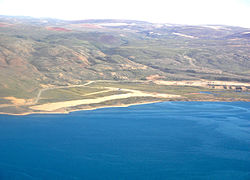
Arctic Bay Airport (IATA: YAB[3], ICAO: CYAB) is an airport located 3 nautical miles (5.6 km; 3.5 mi) southeast of Arctic Bay, Nunavut, Canada. Until January 12, 2010 Nanisivik Airport, about 25 km (16 mi) from Arctic Bay, was used for scheduled flights. On January 13, 2010, First Air transferred all air services to Arctic Bay's newly expanded airport with service to Iqaluit and Resolute Bay. Niore Iqalukjuak, mayor of Arctic Bay, said that the move would save community members $40 for the one way taxi ride. At the same time the Government of Nunavut said that the move would save $600,000 a year because of not having to keep the all-weather road clear.[4]
The original runway at 1,500 ft (457 m) was the shortest in Nunavut. It was decommissioned in 2010 and is now marked off with two "X"s on either ends. A new runway measuring 3,935 ft (1,199 m)[1] was built to the south, along with a new airport terminal. The airport can currently handle general aviation to smaller turboprop aircraft.
^ abCanada Flight Supplement. Effective 0901Z 16 July 2020 to 0901Z 10 September 2020.
^Synoptic/Metstat Station Information Archived June 27, 2013, at the Wayback Machine
^Accident history for Arctic Bay Airport (IATA: YAB) at Aviation Safety Network
^Arctic Bay airport opens[permanent dead link]
and 25 Related for: Arctic Bay Airport information
ArcticBayAirport (IATA: YAB, ICAO: CYAB) is an airport located 3 nautical miles (5.6 km; 3.5 mi) southeast of ArcticBay, Nunavut, Canada. Until January...
2002, the airport was in operation until 2011 and served the community of ArcticBay. This was due to the small size of ArcticBayAirport. However, on...
passing through to other places in the high Arctic such as CFS Alert, Eureka and Mould Bay. Unlike some airports in Nunavut, Resolute is equipped with an...
Nanisivik Airport, located 8 nautical miles (15 km; 9.2 mi) south, was used as the main airport for ArcticBay until 2010, when the lengthened ArcticBay Airport...
operators Nordair in the Eastern Arctic, and Pacific Western Airlines in the West. Wardair also maintained a significant Arctic presence during its existence...
(2012). Encyclopedia of the Arctic. Routledge. p. 1696. ISBN 978-1579584368. Accident history for YMD: Mould BayAirport at Aviation Safety Network v...
the Government of Nunavut. Cambridge Bay is the largest stop for passenger and research vessels traversing the Arctic Ocean's Northwest Passage, a disputed...
Arctic Village Airport (IATA: ARC, ICAO: PARC, FAA LID: ARC) is a public use airport located one nautical mile (1.8 km) southwest of the central business...
headed by Captain Elliott Roosevelt investigated the Frobisher Bay region for a potential airport for use in trans-Atlantic air traffic. Roosevelt's report...
Nanisivik Mine closed in 2002, with Nanisivik Airport closing in 2010 and all flights transferred to ArcticBayAirport. Like the majority of Canada's Inuit communities...
move to Carp Airport, and is still registered under that name. First Air started scheduled operations in 1973, between Ottawa and North Bay. This service...
Ocean in the northeast, while the Foxe Channel connects the Hudson Bay with the Arctic Ocean in the north. It drains a very large area, about 3,861,400 km2...
line and Arctic airbases. Canada continued to operate an administrative and logistical centre for much of the eastern Arctic at Frobisher Bay. In 1964...
Greenland, Aasiaat Airport in the Disko Bay region, Upernavik Airport in Upernavik in northwestern Greenland, and Qaarsut Airport, an airport in Qaarsut, a...
YAB or yab may refer to: ArcticBayAirport Yamaguchi Asahi Broadcasting, A television station in Yamaguchi Prefecture, Japan Yann Arthus-Bertrand (b....
the Labrador Sea. The narrower Nares Strait connects Baffin Bay with the Arctic Ocean. The bay is not navigable most of the year because of the ice cover...
Nunavut. Airport names in italics are part of the National Airports System. With the exception of Iqaluit and Sanikiluaq airports, all other airports in Nunavut...
The Arctic Circle is one of the two polar circles, and the most northerly of the five major circles of latitude as shown on maps of Earth at about 66°...
Cold BayAirport (IATA: CDB, ICAO: PACD, FAA LID: CDB) is a state owned, public use airport located in Cold Bay, a city in the Aleutians East Borough of...
and Dalton highways. It is near Prudhoe Bay and is sometimes also called Prudhoe Airport. Deadhorse Airport covers 6,506 acres (2,633 ha) and has one...
the Baldwin Peninsula in the Northwest Arctic Borough of the U.S. state of Alaska. Ralph Wien Memorial Airport covers an area of 1,480 acres (600 ha)...
 Global Information