This article needs additional citations for verification. Please help improve this article by adding citations to reliable sources. Unsourced material may be challenged and removed. Find sources: "Anupgarh district" – news · newspapers · books · scholar · JSTOR(March 2023) (Learn how and when to remove this message)
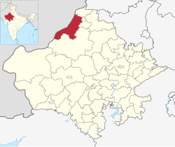
District of Rajasthan in India
Anupgarh district
District of Rajasthan
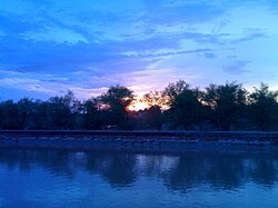
View of canal in tehsil Rawla Mandi of Anupgarh district
Raisinghnagar Anupgarh Ramsinghpur Sri Vijaynagar Gharsana Rawla Mandi
Government
• Type
State Government
• Body
Government of Rajasthan
• District Magistrate
Avdhesh Meena, IAS[1]
• Superintendent of Police
Rajendra Kumar, IPS
Area
• Total
4,713.96 km2 (1,820.07 sq mi)
Population
(2011)[2]
• Total
698,478
• Density
150/km2 (380/sq mi)
Demographics [2]
• Literacy
58.18 %
• Sex ratio
899/1000
Languages
• Official
Hindi[3]
• Additional_official
English[3]
• Most spoken
Punjabi, Bagri, Rajasthani
Time zone
UTC+05:30 (IST)
Major highways
RJ SH 3
Website
official website
Anupgarh district is a new north-west district of Rajasthan state in India. It was established on 7 August 2023 after curving it out of Sri Ganganagar District.
^"Anupgarh - District Administration". Government of Rajathan. Retrieved 25 February 2024.
^ ab"Report of the Commissioner for linguistic minorities: 52nd report (July 2014 to June 2015)" (PDF). Commissioner for Linguistic Minorities, Ministry of Minority Affairs, Government of India. pp. 34–35. Archived from the original (PDF) on 28 December 2017. Retrieved 16 February 2016.
Anupgarhdistrict is a new north-west district of Rajasthan state in India. It was established on 7 August 2023 after curving it out of Sri Ganganagar...
Anupgarh is a town in the state of Rajasthan in India. It is administrative headquarters of the Anupgarhdistrict, which was formed on 17 March 2023....
Anupgarh Tehsil is the one of Seven tehsils of Anupgarhdistrict in Rajasthan, India. The tehsil headquarters are located at the town of Anupgarh. People...
Hanumangarh district, (Hanumangarh district was carved out of it on 12 July 1994) on the south west by Anupgarhdistrict, (Anupgarhdistrict was carved...
irrigated by Anupgarh branch of Indira Gandhi canal: It comprises Anupgarh and Gharsana tehsils. It is the southernmost region of the district, much of which...
Fatehabad district Hisar district Bhiwani district Charkhi Dadri district Bagar tract through Ganganagar district, Anupgarhdistrict, Hanumangarh district, Churu...
the divisions of Rajasthan, India. The division comprises four districts: Bikaner, Anupgarh, Sri Ganganagar and Hanumangarh. Churu was also previously a...
Tehsil is a tehsil located in the south of the Anupgarhdistrict of Rajasthan, India. It is bordered by Anupgarh tehsil in the north, by Chhatargarh, Rawla...
Jaitsar is a town in the Anupgarhdistrictdistrict of Rajasthan, Jaitsar Central State Farm was established in 1964. It is the second largest farm of...
Raisinghnagar is a town and a municipality (Tehsil) in Anupgarhdistrict in the Indian state of Rajasthan. The town is surrounded by fertile land.[citation...
Anupgarh is one of constituencies of Rajasthan Legislative Assembly in the Bikaner Lok Sabha constituency. Anupgarh Constituency covers all voters from...
तहसील, Punjabi: ਰਾਵਲਾ ਮੰਡੀ ਤਹਿਸੀਲ) is one of the 5 tehsils from the Anupgarhdistrict in Rajasthan, India. It was carved out of Gharsana tehsil and given...
Mandi tehsil of Anupgarhdistrict of Rajasthan, India. It is located on Gharsana-Khajuwala road,50 kms from district headquarter Anupgarh and 27 km away...
Raisinghnagar Tehsil is a tehsil of Anupgarhdistrict, Rajasthan, India. It is in the central-western area of the district. Raisinghnagar is the headquarters...
A district (zila), also known as revenue district is an administrative division of an Indian state or territory. In some cases, districts are further...
Bharatpur district Deeg district Dholpur district Gangapur district Karauli district Sawai Madhopur district Bikaner division Anupgarhdistrict Bikaner...
Anupgarh canal is the canal which irrigates agriculture land in the south part of Shri Ganganagar district and north west of Bikaner district of western...
village in Anupgarhdistrict of Rajasthan, India. It is located in the south-western region of Gharsana Tehsil, 74 kilometers from Anupgarhdistrict headquarter...
district. Bagri is the First language in western Fatehabad district Hisar, Bhiwani, Charkhi dadri. Bagri is the First language of Ganganagar district...
Ramjiwala is a small village in the tehsil of Raisingh Nagar, Ganganagar District, in the Indian state of Rajasthan. 29°35′N 78°06′E / 29.583°N 78.100°E...
Anupgarh Assembly Constituency in the erstwhile Ganganagar District. Devi hails from Anupgarh. She did post graduation in law and is a lawyer by profession...
 Global Information