Anstey Hill Recreation Park is a 362-hectare (890-acre) protected area established in 1989 and located approximately 19 kilometres (12 mi) northeast of Adelaide, South Australia. The park is a significant reserve of bushland in the foothills of the Mount Lofty Ranges and is home to rare or vulnerable native plants and animals, and problematic invasive species. It is managed by the City of Tea Tree Gully, the Department of Environment, Water and Natural Resources and a volunteer group—The Friends of Anstey Hill. The park is designed for recreational walking and has no visitor facilities. It is managed in association with the regional planning initiative known as of Yurrebilla, the Greater Mount Lofty Parklands.
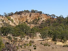
The park's land was gradually acquired by the Government of South Australia beginning in 1966, based on recommendations in a 1962 report. From 1981 onwards, plans were published that aimed to develop the area for commercial purposes, but public pressure led to its declaration as a public reserve in 1989. The last land added was a small area in 2003. Anstey Hill, once known as Anstey's Hill,[4] is a 371-metre-high (1,217 ft) peak in the park's south. Both hill and park are named after a road built by agricultural pioneer George Alexander Anstey. Fire authorities regard the park as an "arson hotspot", and it is frequently burned by bushfires—mostly deliberately lit. There is no permanent water except for springs in Water Gully, adjacent to ruins of a nursery, although there are many seasonal creeks. Much of the land is steep, rising 200 m (660 ft) across the park's breadth, with gradients often steeper than one in three. Erosion and land movements due to a significant geologic fault zone created this land form. The Gun Emplacement, a listed Geologic Monument and remnant of an ancient land surface, lies in the southwestern corner.
The Mannum–Adelaide pipeline crosses the park and the Anstey Hill water filtration plant lies on its southern boundary; together they supply 20% of Adelaide's reticulated water. Significant historical uses of the area are preserved as ruins and highlighted with interpretive signs. The ruins of Newman's Nursery are all that remains of what was once the largest plant nursery in the Southern Hemisphere. Ellis Cottage is one of the earliest homes in the area, and the Rumps Bakery building housed the first bakery in Tea Tree Gully. Quarries supplied stone for significant Victorian buildings in Adelaide and aggregate for road building. Klopper's quarries in the southwest hosted plays for the Festival of the Arts in 1980 and 1988.
^ ab"Terrestrial Protected Areas of South Australia (refer 'DETAIL' tab )". CAPAD 2016. Australian Government, Department of the Environment (DoE). 2016. Retrieved 21 February 2018.
^Blevins, F.T. (31 August 1989). "NATIONAL PARKS AND WILDLIFE ACT, 1972, SECTION 34(1): CONSTITUTION OF ANSTEY HILL RECREATION PARK" (PDF). Government of South Australia. p. 699. Retrieved 9 January 2019.
^"Protected Areas Information System Reserve List" (PDF). Government of South Australia. 9 March 2018. Retrieved 26 April 2018.
^"Deviation at Anstey's Hill". Adelaide Observer. Vol. XXX, no. 1632. South Australia. 11 January 1873. p. 12. Retrieved 14 March 2023 – via National Library of Australia.
and 23 Related for: Anstey Hill Recreation Park information
AnsteyHillRecreationPark is a 362-hectare (890-acre) protected area established in 1989 and located approximately 19 kilometres (12 mi) northeast of...
Melbourne, Victoria AnsteyHillRecreationPark, a public park in Adelaide, South Australia Anstey River, British Columbia Anstey's Cove, a hamlet near...
name AnsteyHill, a geographical feature, and the AnsteyHillRecreationPark in the north eastern suburbs of Adelaide. Gallasch, Kevin. "ANSTEYHILL". Tea...
Provincial Park. Mount Edziza Recreation Area Stikine River Provincial Park Tenh Dẕetle Conservancy "Protected Planet | Mount Edziza Park". Protected...
the eventual name 'Tea Tree Gully'. The 350-hectare (860-acre) AnsteyHillRecreationPark is adjacent to the suburbs of Vista and Tea Tree Gully. The City...
isolated north-western block and Anstey and Paganoni Swamp a separate southern part. The Port Kennedy Scientific Park and Lark Hill block is separated from Lake...
hectares). The park lies between the villages of Newtown Linford, Anstey, Cropston, Woodhouse Eaves and Swithland. The River Lin runs through the park, flowing...
Friends of Parks South Australia, registered as Friends of Parks Inc., (FoPInc), is an independent umbrella organisation established to serve and represent...
Road, just before the latter proceeds into the Adelaide Hills, past AnsteyHillRecreationPark and on towards the towns of Houghton and Inglewood. The...
Shepherds HillRecreationPark is a protected area located about 9 kilometres (5.6 miles) south of the Adelaide city centre in the local government area...
Para Wirra Conservation Park (formerly Para Wirra RecreationPark and Para Wirra National Park) is a 1,417-hectare (3,500-acre) protected area located...
Caratoola RecreationPark (formerly the Caratoola National Parks Reserve) is a protected area in the Australian state of South Australia located in the...
February 1972 along with Mount Edziza Provincial Park. Initially, the 101,171-hectare (249,999-acre) recreation area formed a 1-to-10-kilometre-wide (0.62-to-6...
Coorong National Park is a protected area located in South Australia about 156 kilometres (97 mi) south-east of Adelaide, that predominantly covers a coastal...
is about 20 acres (8.1 ha) and is managed by the Washington State Parks and Recreation Commission. Border inspection services at what is now known as the...
Onkaparinga River RecreationPark is a protected area occupying land in the estuary of the Onkaparinga River in South Australia. The recreationpark which was...
Greenhill Creek RecreationPark is a protected area located in the Australian state of South Australia about 7 kilometres (4.3 miles) east of the Adelaide...
Naracoorte Caves National Park is a national park near Naracoorte in the Limestone Coast tourism region in the south-east of South Australia (Australia)...
Belair National Park (formerly known as the National Park and as Belair RecreationPark) is a protected area in Belair, South Australia, 9 kilometres...
Granite Island RecreationPark is a protected area including all of Granite Island which is about 0.6 kilometres (0.37 miles) south-east of Victor Harbor...
 Global Information