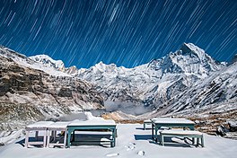
View of Mt. Machapuchare from Annapurna base camp near Fishtail Base Camp
Length
131 kilometres (81 miles)[1]
Location
Nepal
Use
Hiking
Elevation gain/loss
10,107 m (33,159 ft)
Difficulty
Difficult
The Annapurna Circuit is a trek within the mountain ranges of central Nepal. The total length of the route varies between 160–230 km (100-145 mi), depending on where motor transportation is used and where the trek is ended. This trek crosses two different river valleys and encircles the Annapurna Massif. The path reaches its highest point at Thorung La pass (5416m/17769 ft), reaching the edge of the Tibetan plateau. Most trekkers hike the route anticlockwise, as this way the daily altitude gain is slower, and crossing the high Thorong La pass is easier and safer.
The mountain scenery, seen at close quarters includes the Annapurna Massif (Annapurna I-IV), Dhaulagiri, Machhapuchhre, Manaslu, Gangapurna, Tilicho Peak, Pisang Peak, and Paungda Danda. Numerous other peaks of 6000-8000m in elevation rise from the Annapurna range.
The trek begins at Besisahar or Bhulbhule in the Marshyangdi river valley and concludes in the Kali Gandaki Gorge. Besisahar can be reached after a seven-hour drive from Kathmandu. The trail passes along paddy fields and into subtropical forests, past several waterfalls and gigantic cliffs, and through various villages.
Annapurna Circuit has been voted the best long-distance trek in the world, as it combined, in its old full form, a wide variety of climate zones from the tropics at 600 m asl to the Arctic at 5416 m asl at the Thorong La pass and cultural variety from Hindu villages at the low foothills to the Tibetan culture of Manang Valley and lower Mustang. Continuing construction of a road has shortened the trail and changed the villages. The Beisahar-Manag road has been built which passes through the trekking trail much of the time. With the construction of roads, mountain biking is becoming popular, with Mustang, in particular.
The AnnapurnaCircuit is a trek within the mountain ranges of central Nepal. The total length of the route varies between 160–230 km (100-145 mi), depending...
home to several world-class treks, including Annapurna Sanctuary and AnnapurnaCircuit. For decades, Annapurna I held the highest fatality-to-summit rate...
Conservation Area encompasses Annapurna Sanctuary and is known for several trekking routes including the AnnapurnaCircuit. The Annapurna Conservation Area was...
and daughter of multibillionaire Larry Ellison. She is the founder of Annapurna Pictures, established in 2011. She produced the films Zero Dark Thirty...
Lake is the destination of one of the most popular side hikes of the AnnapurnaCircuit trek. The hike takes additional 3–4 days. No camping is required,...
for treks in the Annapurna range of Nepal (Annapurna Base camp and AnnapurnaCircuit treks, in particular). The peaks of Mt Annapurna, Mt Machapuchare...
Manaslu massif over the pass down to Annapurna. The Nepalese Government only permitted trekking on this circuit in 1991. The trekking trail follows an...
west. Thorong La is the highest point on the AnnapurnaCircuit, a 300 km (190 mi) route around the Annapurna mountain range. In addition to trekkers, the...
base for trekkers undertaking the AnnapurnaCircuit through the Annapurna Conservation Area region of the Annapurna ranges in the Himalayas. The city...
of Pokhara, Nepal. The beautiful tourist village is surrounded by AnnapurnaCircuit. The SAARC Village Tourism Museum is one of the attraction of Ghalegaun...
of Muktinath as well as for trekkers on the popular AnnapurnaCircuit that runs around the Annapurna-Himal. When trekking clockwise, Ranipauwa is the last...
as one of its tributaries.[citation needed] The beginning of the AnnapurnaCircuit trekking route follows the Marshyangdi river valley.[citation needed]...
trekking route from Pokhara to Muktinath, part of the AnnapurnaCircuit. The gorge is within the Annapurna Conservation Area. The pass at the head of the Kali...
year. International tourists visit Muktinath mainly en route to the AnnapurnaCircuit Trek. The route to Muktinath is also popular among the biking community...
September 2023.{{cite web}}: CS1 maint: archived copy as title (link) AnnapurnaCircuit Trail in Manang Wikimedia Commons has media related to Manang. v t...
Among the dead were 21 trekkers from several countries walking the AnnapurnaCircuit, including two Slovak climbers at Dhaulagiri base camp, and several...
trekking in the AnnapurnaCircuit. In addition to trekking routes through the Lo Kingdom (Upper Mustang) and along the AnnapurnaCircuit (lower Mustang)...
Most of the route along the Jomsom trek forms part of the Annapurnacircuit and Annapurna foothill treks. The usual starting point is Naya Pul on the...
back, is known to be the third most popular trek in Nepal, after the AnnapurnaCircuit and Everest Base Camp (EBC) treks. There are several treks that go...
(Jong Ri) is a pyramidal trekking peak above Pisang, a village on the AnnapurnaCircuit, within the Manang District, northern Nepal. It was first climbed...
Sorkhabi; Jay Quade (eds.). "High strain zone in the hanging wall of the Annapurna detachment". Himalaya and Tibet: Mountain Roots to Mountain Tops (328)...
under construction to many remote places, such as the villages of the AnnapurnaCircuit, and a road was completed in 2013 to Mêdog County. Additional intercontinental...
activities such as nature hikes can be ecologically destructive. In the AnnapurnaCircuit in Nepal, ecotourists have worn down the marked trails and created...
Waterfall , falls like the legs of an Octopus. On the world famous AnnapurnaCircuit, Marsyandi Rural Municipality, Lamjung District 100 m Sunchhari WaterFall...
northern Nepal. It lies on the Marshyangdi River, in the foothills of Manaslu and Annapurna and is often bypassed on the AnnapurnaCircuit Trek. v t e...
trekkers and tourists. The village is a common overnight halt on the AnnapurnaCircuit, less crowded and touristy[citation needed] than Jomsom to the north...
 Global Information