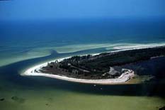
Anclote Key is a barrier island off the Gulf Coast of the U.S. state of Florida, the largest island in the Anclote Keys, located at 28°11′16″N82°50′44″W / 28.18778°N 82.84556°W / 28.18778; -82.84556 (Anclote Key) near Tarpon Springs. Its name originates from the Spanish term for "anchor."[1] The island is accessible only by boat and is split between Anclote Key Preserve State Park and Anclote National Wildlife Reserve. North Anclote Bar, South Anclote Bar, and Three Rooker Island (south of Anclote Key) are part of Anclote Key Preserve State Park.[2] The island contains mangrove wetlands, coastal pine flatwoods, and beaches. A large number of shorebirds nest and breed on Anclote Key and the surrounding islands. Sand Key is located nearby. Most of the island is located within Pasco County, while its southernmost section is in Pinellas County. The island is home to the Anclote Keys Light.
Anclote Key is the northernmost barrier island on the Gulf coast of the Florida peninsula.[a] It is a wave-dominated barrier island, 3 miles (4.8 km) long, with tidal channels at each end. A mangrove forest extends along the landward side of the island. Radiocarbon dating indicates that the island has existed for about 1,200 to 1,500 years. Sand dunes up to 10 feet (3.0 m) tall occur on the island. Anclote Key has lengthened considerably since 1960, especially on the northern end. This growth has blocked the channel at the north end of the island.[3]
In the 1990s sand bars developed off both the north and south ends of the island, blocking the shallow tidal channels there. Both shoals grew and emerged above water. The new islands are now vegetated, and are known as North Anclote Bar and South Anclote Bar, respectively. The area around Anclote Key had little sand available for deposition on shoals and barriers in the middle of the 20th century. There was sand on the Gulf bottom, but it was anchored by beds of seagrass that extended almost up to the surf zone. In, or shortly after, 1960, the sea grass disappeared, and the bottom sand became available for transportation by wave and current action, providing material for those islands.[4]
^Anclote Key Lighthouse Page. "History". Archived from the original on 2011-09-28. Retrieved 2008-02-09.
^"Anclote Key Preserve State Park". Florida State Parks. Retrieved 2023-07-09.
^Davis (2016), pp. 49, 51–56
^Davis (2016), pp. 11–12, 53–54, 55–56
Cite error: There are <ref group=lower-alpha> tags or {{efn}} templates on this page, but the references will not show without a {{reflist|group=lower-alpha}} template or {{notelist}} template (see the help page).
AncloteKey is a barrier island off the Gulf Coast of the U.S. state of Florida, the largest island in the AncloteKeys, located at 28°11′16″N 82°50′44″W...
AncloteKey Preserve State Park is a Florida State Park and historic site, located on AncloteKey three miles (5 km) off Tarpon Springs along the Atlantic...
Pinellas County, Florida. The island is west of Tarpon Springs, south of AncloteKey and north of Honeymoon Island. It is accessible only by boat and its...
roughly from west to east, Loggerhead Key, Garden Key, Bush Key, Long Key, Hospital Key, Middle Key, and East Key. The total land area within the park...
Apalachee Bay down the west coast of peninsular Florida to the Anclote River or AncloteKey. It partially overlaps the coast line of the Big Bend region...
including: the North and South Anclote Bars associated with AncloteKey, Three Rooker Island, Shell Key, and South Bunces Key. American geologist Grove Karl...
lower Florida Keys. U.S. 1 (the Overseas Highway) crosses the key at approximately mile markers 36-38.5, between Ohio Key and Spanish Harbor Key 12 miles (19 km)...
Indian Key Historic State Park is an island within the Florida State Park system, located just a few hundred yards southeast of U.S. 1 within the Florida...
Egmont Key National Wildlife Refuge and State Park is a National Wildlife Refuge and State Park located on the island of Egmont Key, at the mouth of Tampa...
Landmarks: Florida". National Park Service. Retrieved May 19, 2012. "AncloteKey Preserve State Park". State of Florida. Retrieved July 4, 2012. "Hontoon...
The Florida Keys National Marine Sanctuary is a U.S. National Marine Sanctuary in the Florida Keys. It includes the Florida Reef, the only barrier coral...
Madira Bickel Mound Mound Key San Pedro Underwater Preserves and reserves Allen David Broussard Catfish Creek AncloteKey Cedar Key Scrub Charlotte Harbor...
Madira Bickel Mound Mound Key San Pedro Underwater Preserves and reserves Allen David Broussard Catfish Creek AncloteKey Cedar Key Scrub Charlotte Harbor...
Coast from Key West to Jupiter Inlet, and up the West Coast from Marco Island to Sarasota. Many of the smallest coral islands in the Florida Keys are known...
Florida, and has become part of the Everglades National Park. Paradise Key is located southwest of Homestead, Florida. It is a hammock in the Everglades...
Perdido Key State Park is a 247-acre (1.00 km2) Florida State Park located on a barrier island fifteen miles (24 km) southwest of Pensacola, off S.R....
Madira Bickel Mound Mound Key San Pedro Underwater Preserves and reserves Allen David Broussard Catfish Creek AncloteKey Cedar Key Scrub Charlotte Harbor...
"Stronger (What Doesn't Kill You)" include the mermaids of Weeki Wachee Springs. Key scenes from Amy Seimetz's directorial debut Sun Don't Shine take place at...
Madira Bickel Mound Mound Key San Pedro Underwater Preserves and reserves Allen David Broussard Catfish Creek AncloteKey Cedar Key Scrub Charlotte Harbor...
separately in the winter, with Monty in Galveston, Texas, and Rose in AncloteKey, Florida. The pair, who had previously tried and failed to nest in a...
The Passage Key National Wildlife Refuge is part of the United States National Wildlife Refuge (NWR) System, located offshore from St. Petersburg. The...
Twenty-eight miles (45 km) of trails start near the Long Pine Key campgrounds and wind through Long Pine Key, well-suited for offroad cycling through the pine rocklands...
 Global Information