Zealand River, Little River, Gale River, Wild Ammonoosuc River
"Upper Falls of the Ammonoosuc, White Mountains, N.H." stereoscopic image by the Bierstadt Brothers
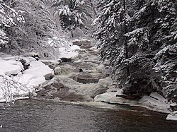
The Ammonoosuc River is a 55-mile-long (89 km) river in northwestern New Hampshire in the United States.[1][2] It is a tributary of the Connecticut River, which flows to Long Island Sound. Ammonoosuc is Abnaki for "small, narrow fishing place".[3]
The Ammonoosuc rises on the western slope of Mount Washington,[1] in Sargent's Purchase in the White Mountains of southern Coos County. One branch of the river is the outlet of the Lakes of the Clouds in the saddle between Mount Washington and Mount Monroe. Leaving the vicinity of the Presidential Range, the river flows westwardly into Grafton County, where it turns southwestwardly. Along its course the Ammonoosuc passes through Chandler's Purchase, Bean's Grant, and Crawford's Purchase; and the towns of Carroll, Bethlehem, Littleton, Lisbon, Landaff, Bath, and Haverhill to the village of Woodsville, where it flows into the Connecticut River. It collects the Gale River in Lisbon, and the Wild Ammonoosuc River in Bath.[4]
Ammonoosuc River behind downtown Littleton
^ ab"Columbia Gazetteer of North America entry". Archived from the original on 2005-12-08. Retrieved 2006-05-24.
^U.S. Geological Survey Geographic Names Information System: Ammonoosuc River
^Huden, John C. (1962) Indian Place Names of New England, Museum of the American Indian Heye Foundation
^DeLorme (1999). New Hampshire Atlas & Gazetteer. Yarmouth, Maine: DeLorme. ISBN 0-89933-242-0
The AmmonoosucRiver is a 55-mile-long (89 km) river in northwestern New Hampshire in the United States. It is a tributary of the Connecticut River, which...
The Wild AmmonoosucRiver is a tributary of the AmmonoosucRiver, about 15 miles (24 km) long, in northwestern New Hampshire in the United States. Via...
The Upper AmmonoosucRiver is a tributary of the Connecticut River that flows through Coös County in the northern part of the northeastern U.S. state of...
Isinglass River Israel River Johns River Jones Brook Knox River Lamprey River Lane River Little River (AmmonoosucRiver tributary) Little River (Big River tributary)...
Ompompanoosuc River (Norwich, VT) Waits River (Bradford, VT) Oliverian Brook (Haverhill, NH) Wells River (Wells River, VT) AmmonoosucRiver (Woodsville...
Ammonoosuc or Ammonusuc may refer to: AmmonoosucRiver, in New Hampshire USS Ammonusuc (AOG-23), naval ship Upper AmmonoosucRiver, distinct from the Ammonoosuc...
New Hampshire. The lakes form the source of the AmmonoosucRiver, a tributary of the Connecticut River. They are recorded by the Geographic Names Information...
Zealand River is a 6.3-mile-long (10.1 km) river in the White Mountains of New Hampshire in the United States. It is a tributary of the AmmonoosucRiver and...
Gale River is a 13.1-mile-long (21.1 km) tributary of the AmmonoosucRiver in northwestern New Hampshire in the United States. Via the Ammonoosuc, it is...
to the AmmonoosucRiver, a tributary of the Connecticut River. The notch is traversed by U.S. Route 302, which closely follows the Saco River southeast...
that flows into Lafayette Brook, then the Gale River, the AmmonoosucRiver, and finally the Connecticut River, which enters Long Island Sound at Old Saybrook...
The Ammonoosuc Volcanics is a rock unit in parts of New Hampshire and Vermont in the United States. This unit is named for the AmmonoosucRiver that runs...
Kelsey drains into Phillips Brook, thence into the Upper AmmonoosucRiver, the upper Connecticut River, and into Long Island Sound in Connecticut. New Hampshire...
the Wild AmmonoosucRiver, then climbs through Kinsman Notch. NH 112 crosses into the town limits of Woodstock and descends along the Lost River, meeting...
Hampshire, United States, situated along the headwaters of the Connecticut River. They are accessed via the northernmost segment of U.S. Route 3, between...
River, a different stream which is also a tributary of the Androscoggin River. The northwest side of Crescent drains into the Upper AmmonoosucRiver,...
 Global Information