This article possibly contains original research. Please improve it by verifying the claims made and adding inline citations. Statements consisting only of original research should be removed.(November 2010) (Learn how and when to remove this message)
Amlwch (Welsh:[ˈamlʊχ]) is a port town and community in Wales. It is situated on the north coast of the Isle of Anglesey, on the A5025 which connects it to Holyhead and to Menai Bridge. As well as Amlwch town and Amlwch Port, other settlements within the community include Burwen, Bull Bay (Porthllechog) and Pentrefelin. The town has a beach in Llaneilian, and it has significant coastal cliffs. Tourism is an important element of the local economy. At one time it was a booming mining town that became the centre of a vast global trade in copper ore. The harbour inlet became a busy port and significant shipbuilding and ship repair centre, as well as an embarkation point with boats sailing to the Isle of Man and to Liverpool. The community covers an area of about 15 square kilometres.[1]
^UK Census (2011). "Local Area Report – Amlwch Parish (W04000002)". Nomis. Office for National Statistics. Retrieved 25 August 2020.
[failed verification] the largest settlements are Llangefni (5,500) and Amlwch (3,967). The economy of the county is mostly based on agriculture, energy...
Railway (Welsh: Lein Amlwch, Amlwch Line) was a 17.5-mile (28.2 km) standard-gauge railway in Anglesey, Wales, connecting the port of Amlwch and the county...
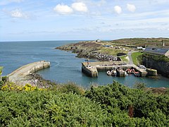
Amlwch Port (Welsh: Porth Amlwch) is a port village in Anglesey, Wales. It is effectively an eastern suburb of the larger town of Amlwch.[citation needed]...
Melin Adda Melin Adda is a windmill near Amlwch, Anglesey, (OS reference: SH 440921) which was built in the 1790s and closed down in 1912. The mill was...
to live in Bull Bay, Anglesey, Wales in 1976. He attended Ysgol Gynradd Amlwch and then Ysgol Syr Thomas Jones until the age of 18. He studied civil engineering...
The Amlwch Lighthouse (Grid reference: SH 452937) is a lighthouse tower situated on the outer pier of Amlwch, at the northeast tip of Anglesey, Wales....
electoral ward in the north of Anglesey, Wales. It includes the communities of Amlwch, Llanbadrig, Llaneilian, and Rhosybol. Twrcelyn elects three county councillors...
Parys Mountain (Welsh: Mynydd Parys) is located south of the town of Amlwch in north east Anglesey, Wales. Originally known as Trysclwyn, the high ground...
Amlwch railway station was the original terminus of the Anglesey Central Railway line from Gaerwen. A light railway extension was later added for freight...
Machine Summers, Neil (4 November 2006). "Welsh surnames and their meaning". Amlwch history databases. Archived from the original on 19 May 2012. Retrieved...
War 1946–47 – Amlwch Town (fixtures not completed) 1947–48 – Amlwch Town 1948–49 – Amlwch Town 1949–50 – Amlwch Town 1950–51 – Amlwch Town 1951–52 –...
engraving". British Museum – via Google Arts & Culture. "Beer Houses". AMLWCH History. Archived from the original on 17 December 2007. "Beer Houses"....
parabolic-arched church of Our Lady Star of the Sea and St Winefride in Amlwch, Anglesey. He designed three churches in north Wales, all of which are now...
between a fricative and a fricative trill. neck [nɛχ] 'neck' Welsh Amlwch [ˈamlʊχ] 'Amlwch' Occurs only in loanwords from Welsh; usually transcribed in IPA...
Holyhead Gwynedd LL LL66 Rhosgoch Gwynedd LL LL67 Cemaes Bay Gwynedd LL LL68 Amlwch Gwynedd LL LL69 Penysarn Gwynedd LL LL70 DULAS Gwynedd LL LL71 LLANERCHYMEDD...
Contents A B C D E F G H I J K L M N O P Q R S T U V W X Y Z Aberffraw AmlwchAmlwch Port Beaumaris Benllech Bodafon Bodedern Bodewryd Bodffordd Bodorgan...
Line) Conwy Penmaenmawr Llanfairfechan Bangor Llanfairpwll Line diverges to Amlwch (Anglesey Central Railway, disused) Bodorgan Ty Croes Rhosneigr Valley Freight...
 Global Information