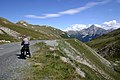
The Albula Pass (Romansh: Pass d'Alvra[2] or Pass da l'Alvraⓘ,[3] German: Albulapass) (el. 2312 m) is a Swiss mountain pass in the canton of Graubünden. It lies at the heart of the Albula Alps, on the watershed between the Albula, tributary of the Rhine and the Ova d'Alvra, tributary of the Inn. Overlooking the pass are the ranges of Piz Üertsch (north) and Crasta Mora (south).[4]
The Albula Pass is an important axis from central Graubünden to Engadin. It is traversed by a paved road from Thusis to La Punt, via Bergün. It is also traversed by the Albula Railway, although at a lower elevation through the Albula Tunnel (1,820 m), from Thusis to Bever, also via Bergün.
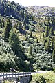
On the summit of the pass is a hospice. East of the pass, on the Engadin side, is a lake named Albulasee (2,294 m) which is 4.2 ha large.[5] West of the pass, at a further distance, is the larger Lai da Palpuogna, a popular stop on the Albula road.
The Albula Pass is one of the three paved road passes connecting the Engadin with the northern Grisons, the two other being the Julier Pass and the Flüela Pass.[4]
Albula Pass
Albula Railway
Lai da Palpuogna
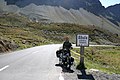
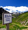
Old road sign on the top
^Albula Pass, Swisstopo topographic maps
^Swisstopo maps, official maps of Switzerland by the Swiss government
^"Pass da l'Alvra in the Pledari Grond dictionary". Archived from the original on 2011-07-07. Retrieved 2008-07-24.
^ abTopographic map of the Grisons, Swisstopo. Retrieved 16 March 2022
The AlbulaPass (Romansh: Pass d'Alvra or Pass da l'Alvra, German: Albulapass) (el. 2312 m) is a Swiss mountain pass in the canton of Graubünden. It lies...
Julier Pass (Romansh: Pass dal Güglia, German: Julierpass, Italian Passo del Giulia) (el. 2284 m) is a mountain pass in Switzerland, in the Albula Alps...
after the river Albula. According to AVE (see map), the Albula Alps are separated from the Oberhalbstein Alps in the west by the Septimer Pass and the valley...
with many spirals. Then the train enters the Albula Tunnel at 1,815 m (5,955 ft) under the AlbulaPass. It emerges in the Val Bever, where it reaches...
The Albula Tunnel is the centrepiece of the Albula Railway, which forms part of the Rhaetian Railway network, in the Canton of Graubünden, Switzerland...
much of its journey, it also passes along and through the World Heritage Site known as the "Rhaetian Railway in the Albula / Bernina Landscapes". The first...
tributary of the Hinterrhein Albula District, a district in canton Graubünden until 2017 Albula/Alvra, a municipality AlbulaPassAlbula Railway, part of the...
Bernina Pass at 2,254 metres (7,395 ft) above sea level and runs down to Tirano, Lombardy in Italy. In 2008, the RhB section from the Albula/Bernina area...
The Albula railway line (German: Albulalinie; Italian: Linea dell'Albula; Romansh: Lingia da l'Alvra) is a single track metre gauge railway line forming...
Mäder died in hospital in Chur after a heavy crash on the descent of the AlbulaPass during stage 5. Stage 6 was neutralised and a short homage to Mäder was...
valley of the Albula Alps. It lies on the road over the AlbulaPass at 1789 metres above sea level (a.s.l.) and at the north portal of the Albula Tunnel of...
hillside with a view to the west where the two rivers Albula/Alvra from the AlbulaPass and Landwasser from Davos meet. On 1 January 2018 the former municipalities...
Near Sils the Posterior Rhine is joined by the Albula, from the east, from the AlbulaPass region. The Albula draws its water mainly from the Landwasser with...
The main passes connecting the Engadin with the northern Grisons are (from west to east): the Julier Pass, the AlbulaPass and the Flüela Pass. The valleys...
300 ft) in elevation. The Engadine is connected by the Julier, Albula, and Flüela Passes and the Vereina Tunnel to the northern part of Switzerland and...
Mäder fell in a turn when descending from the stage's highest point at AlbulaPass. Mäder, 26, was found to be unconscious and submerged in water. He was...
posterior Rhine Albula Landwasser (Davos) Oberhalbstein (Julier Pass connects to the Inn basin) Albulatal, Bergün, Preda (AlbulaPass connects to the...
create a region of plasma around the electrode. The ions generated eventually pass the charge to nearby areas of lower potential, or recombine to form neutral...
headwater of the Albula flows east from Bergün About 53 km: a headwater of the Albula descending from the Crap Alv Laiets near the AlbulaPass The longest...
of Switzerland Retrieved from the Swisstopo maps. The key col is the AlbulaPass (2,383 m). Retrieved from Google Earth. The nearest point of higher elevation...
Albula Alps, located north of the AlbulaPass in the canton of Graubünden. Its summit is the tripoint between the Val Tuors, the Val d'Alvra (Albula valley)...
Lunghin west of the Maloja Pass. The divide continues northwards along the Albula Alps to Julier Pass, AlbulaPass and Flüela Pass south of Davos, between...
north side lies the Porchabella Glacier. West of Piz Kesch lies the AlbulaPass (Pass d'Alvra in Rumantsch); to the north lies the valley of Davos, and...
 Global Information

 Albula Railway
 Lai da Palpuogna

 Old road sign on the top