Maintained by Alberta Transportation, the City of Wetaskiwin, and the City of Camrose
Length
366.0 km[1] (227.4 mi)
Major junctions
West end
Range Road 74 near Alder Flats
Major intersections
Hwy 22 near Alder Flats
Hwy 20 near Winfield
Hwy 2 near Wetaskiwin
Hwy 2A in Wetaskiwin
Hwy 21 near Camrose
Hwy 26 in Camrose
Hwy 56 near Camrose
Hwy 36 in Killam
Hwy 41 near Czar
East end
Hwy 14 near Hayter at the Saskatchewan border
Location
Country
Canada
Province
Alberta
Specialized and rural municipalities
Wetaskiwin No. 10 County, Camrose County, Flagstaff County, Provost No. 52 M.D.
Major cities
Wetaskiwin, Camrose
Towns
Daysland, Killam, Sedgewick, Hardisty, Provost
Villages
Bittern Lake, Bawlf, Lougheed, Amisk, Hughenden
Highway system
Provincial highways in Alberta
← Hwy 12
→ Hwy 14
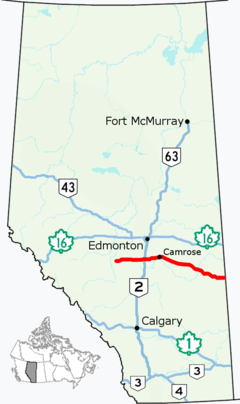
Alberta Provincial Highway No. 13, commonly referred to as Highway 13, is an east–west highway through central Alberta. It runs from Alder Flats, 7 km (4 mi) west of Highway 22, to the Alberta-Saskatchewan border, where it becomes Saskatchewan Highway 14.[2] Highway 13 is about 366 kilometres (227 mi) long.[1] East of the City of Wetaskiwin, it generally parallels a Canadian Pacific Kansas City rail line.
^ abCite error: The named reference overmap was invoked but never defined (see the help page).
^"2015 Provincial Highways 1 - 216 Series Progress Chart" (PDF). Alberta Transportation. March 2015. Retrieved 2016-03-23.
and 28 Related for: Alberta Highway 13 information
Alberta Provincial Highway No. 13, commonly referred to as Highway13, is an east–west highway through central Alberta. It runs from Alder Flats, 7 km...
The Canadian province of Alberta has a provincial highway network consisting of over 31,400 kilometres (19,500 mi) of roads as of 2021-2022, of which 28...
KML/AlbertaHighway 2 KML is not from Wikidata Alberta Provincial Highway No. 2, commonly referred to as Highway 2 or the Queen Elizabeth II Highway, is...
Alberta Provincial Highway No. 22, commonly referred to as Highway 22 and officially named Cowboy Trail, is a 584-kilometre (363 mi) highway in the Canadian...
Alberta Provincial Highway No. 1, commonly referred to as Highway 1, is a major east–west highway in southern Alberta that forms the southern mainline...
Alberta Provincial Highway No. 16, commonly referred to as Highway 16, is a major east–west highway in central Alberta, Canada, connecting Jasper to Lloydminster...
Alberta Provincial Highway No. 1A is the designation of two alternate routes off the Alberta portion of Trans-Canada Highway 1. However, it is not the...
Alberta Provincial Highway No. 2A is the designation of six alternate routes off Highway 2 in Alberta, Canada. In general, these are original sections...
KML/AlbertaHighway 9 KML is not from Wikidata Alberta Provincial Highway No. 9, commonly referred to as Highway 9, is a highway in south-central Alberta...
Alberta Provincial Highway No. 4, commonly referred to as Highway 4, is a 103-kilometre (64 mi) highway in southern Alberta, Canada that connects Highway 3...
Template:Attached KML/AlbertaHighway 41 KML is not from Wikidata Alberta Provincial Highway No. 41, commonly referred to as Highway 41 and officially named...
Alberta Provincial Highway No. 40, commonly referred to as Highway 40, is a south–north highway in western Alberta, Canada. It is also named Bighorn Highway...
Template:Attached KML/AlbertaHighway 43 KML is not from Wikidata Alberta Provincial Highway No. 43, commonly referred to as Highway 43, is a major highway in northern...
Alberta Provincial Highway No. 3, commonly referred to as Highway 3 and officially named the Crowsnest Highway, is a 324-kilometre (201 mi) highway that...
Alberta Provincial Highway No. 21, commonly referred to as Highway 21, is a north–south highway in Alberta, Canada that parallels Highway 2 between Calgary...
Highway 93 is a north–south highway in Alberta, Canada. It is also known as the Banff-Windermere Parkway south of the Trans-Canada Highway (Highway 1)...
Alberta Provincial Highway No. 88, commonly referred to as Highway 88 and officially named the Bicentennial Highway, is a north–south highway in Northern...
Alberta Provincial Highway No. 63, commonly referred to as Highway 63, is a 434-kilometre (270 mi) highway in northern Alberta, Canada that connects the...
Alberta Provincial Highway No. 12, commonly referred to as Highway 12, is an east-west highway through central Alberta. It runs from Highway 22, through...
Template:Attached KML/AlbertaHighway 36 KML is not from Wikidata Alberta Provincial Highway No. 36, commonly referred to as Highway 36 and officially named...
Alberta Provincial Highway No. 14, commonly referred to as Highway 14, is an east-west highway in central Alberta, Canada. It stretches from Edmonton...
Alberta Provincial Highway No. 20, commonly referred to as Highway 20, is a highway in central Alberta, Canada, west of Highway 2. Highway 20 begins Highway 11...
Alberta is one of the thirteen provinces and territories of Canada. It is a part of Western Canada and is one of the three prairie provinces. Alberta...
Mackenzie Highway is a Canadian highway in northern Alberta and the Northwest Territories. It begins as AlbertaHighway 2 at Mile Zero in Grimshaw, Alberta. After...
Alberta Provincial Highway No. 64 is an east-west highway in northern Alberta, Canada. In the west, Highway 64 begins at the Alberta/British Columbia border...
Alberta Provincial Highway No. 881, commonly referred to as Highway 881, is a highway split into two sections in northeast Alberta, Canada. Each section...
Highway 19 and Highway 625 are two provincial highways south of Edmonton in the Canadian province of Alberta that form a continuous east–west route connecting...
Kabul–Behsud Highway – National Highway13 Mount Lindesay Highway – National Route 13 - SA Brenner Autobahn Route 13 (Bolivia) AlbertaHighway13 British Columbia...
 Global Information