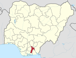
Abia State (Igbo: Ȯha Abia) is a state in the South-East geopolitical zone of Nigeria, it is bordered to the northwest by Anambra State and northeast by the states of Enugu, and Ebonyi, Imo State to the west, Cross River State to the east, Akwa Ibom State to the southeast, and Rivers State to the south. Abia is the only Southeastern state that has boundaries with the other four Southeastern states in Nigeria. [5] It takes its name from the acronym for four of the state's most populated regions: Aba, Bende, Isuikwuato, and Afikpo (but Afikpo was later joined with a part of Enugu state to create Ebonyi state in 1996).[6] The state capital is Umuahia while the largest city and commercial centre is Aba.[7][8]
Abia is the 32nd largest in area and 27th most populous with an estimated population of over 3,727,347 as of 2016.[9] Geographically, the state is divided between the Niger Delta swamp forests in the far south and the drier Cross–Niger transition forests with some savanna in the rest of the State. Other important geographical features are the Imo and Aba Rivers which flow along the Abia's western and southern borders, respectively.
Modern-day Abia State has been inhabited for years by various ethnic groups, but it is predominantly inhabited by the Igbo people. In the pre-colonial period, what is now Abia State was a part of Arochukwu-based Aro Confederacy before the confederacy was defeated in the early 1900s by British troops in the Anglo-Aro War. After the war, the British incorporated the area into the Southern Nigeria Protectorate which later merged into British Nigeria; after the merger, Abia became a centre of anti-colonial resistance with the Women's War that started in Oloko.
After independence in 1960, the Abia was a part of the post-independence Eastern Region until 1967 before the region was split and it became part of the East Central State. Less than two months afterwards, the former Eastern Region attempted to secede in the three-year long Nigerian Civil War with Abia as a part of the secessionist state of Biafra. At the war's end and for the reunification of Nigeria, the East Central State was merged as one until 1976 when Imo State (including now-Abia) was formed by the Murtala Muhammed regime. Fifteen years afterwards, Imo State was divided with eastern Imo being broken off to form the old Abia State; but in 1996, part of Abia's northeast was removed to form a part of the new Ebonyi State.[10]
Economically, Abia State is based around the production of crude oil and natural gas along with agriculture, mainly of yams, maize, taro, oil palm, and cassava. A key minor industry is manufacturing, especially in and around Aba.[11] With its fast growing population and industrialization, Abia has the joint-eighth highest Human Development Index in the country.[12]
^See List of governors of Abia State for a list of prior governors
^"Abia State: Subdivision". www.citypopulation.de. Retrieved 5 February 2024.
^ abOkeowo, Gabriel; Fatoba, Iyanuoluwa, eds. (13 October 2022). "State of States 2022 Edition" (PDF). Budgit.org. BudgIT. Retrieved 7 March 2023.
^"Sub-national HDI – Area Database – Global Data Lab". hdi.globaldatalab.org. Retrieved 13 September 2018.
^Nigeria, Media (2 December 2023). "Which States Share Border With Abia State". Media Nigeria. Retrieved 30 January 2024.
^"History of Abia State Nigeria". Retrieved 18 September 2021.
^"Aba | History & Facts | Britannica". www.britannica.com. Retrieved 12 March 2022.
^Esochaghi, Gift; Bukola (14 May 2023). "Aba: Once Abandoned Commercial City Undergoes Regeneration". New Telegraph. Retrieved 25 July 2023.
^Owoh, Uzondu Roy (7 May 2023). "Figure 1. Map of abia State showing the 17 local government areas". ResearchGate. Retrieved 12 March 2022.
^"This is how the 36 states were created". Pulse.ng. Retrieved 15 December 2021.
^"Abia". Encyclopædia Britannica. Retrieved 14 December 2021.
^"Human Development Indices". Global Data Lab. Retrieved 15 December 2021.
AbiaState (Igbo: Ȯha Abia) is a state in the South-East geopolitical zone of Nigeria, it is bordered to the northwest by Anambra State and northeast...
AbiaState University Uturu (ABSU) is a Nigerian public university. It is one of the state-owned universities in Nigeria. These state academic institutions...
governor of AbiaState is the head of government of AbiaState in Nigeria. The governor is the head of the executive branch of the AbiaState Government...
administrators and governors of AbiaState, Nigeria, which was created on 1991-08-27, when it was split from Imo State. * Military administrators appointed...
AbiaState Polytechnic is a state government owned Polytechnic established in 1992 and located in Aba, AbiaState, Nigeria. The Polytechnic is composed...
west and south, and AbiaState to the east. It takes its name from the Imo River which flows along the state's eastern border. The state capital is Owerri...
This is a list of INEC Polling Units in AbiaState, Nigeria organised by local government area (LGA) and district/area (with postal codes also given)....
River State to the east and southeast, and AbiaState to the southwest. Named for the Abonyi (Aboine) River—a large part of which is in the state's south—Ebonyi...
Igbo subgroup that originated from the Arochukwu kingdom in present-day Abiastate, Nigeria. The Aros can also be found in about 250 other settlements mostly...
The following is a list of Nigerian state capitals. Olatunji, Jessica (2018-06-01). "Do you know all the states and capitals of Nigeria?". Legit.ng -...
investor, philanthropist, and politician, serving as the current Governor of AbiaState in Nigeria. He is from Isiala-ngwa. Otti is the former Group Managing...
AbiaState House of Assembly is the legislative arm of the AbiaState Government. It is a unicameral body consisting of 24 members elected into 24 state...
the Local Government, the third tier of government in Nigeria, below the state governments and the federal government. The functions of local governments...
Broadcasting Corporation of AbiaState (BCA) is a state government-run radio station of AbiaState. Established on November 16, 1992, the broadcaster transmits...
1982, in Umuahia the capital city of AbiaState. He hails from Okoko Item, Bende Local Government Area of AbiaState, Nigeria. Eze grew up in Umuahia where...
Region, Rivers State borders include Imo and Anambra to the north, Abia and Akwa Ibom to the east, and Bayelsa and Delta to the west.The State capital, Port...
of Benue and Kogi, Ebonyi State to the east and southeast, AbiaState to the south, and Anambra State to the west. The state takes its name from its capital...
Umuahia (pronounced [ʊmʊaːhiaː]) is the capital city of AbiaState in southeastern Nigeria. Umuahia is located along the rail road that lies between Port...
Nigerian engineer and politician who has served as deputy governor of AbiaState since 2023. Emetu is from Ohafia. He is a petrochemical engineer. According...
the north through Benue state, to the west through Ebonyi state and Abiastate, and to the southwest through Akwa Ibom state, while its eastern border...
of Nigeria, and the dates of their creation. How Nigeria got to 36 States. Timeline of State creation in Nigeria. Old Naija. Retrieved June 25, 2020....
The government of AbiaState is the supreme governing authority of AbiaState and its local governments. It consists of the executive headed by the governor...
old Afikpo division of AbiaState by Abacha's government. States of Nigeria List of state governors of Nigeria "Ebonyi State Government". www.ebonyistate...
elections in AbiaState was held on 25 February 2023, to elect the 3 House of Representatives members from AbiaState, one from each of the state's three senatorial...
Abam is a populated Igbo clan in Abiastate. It is located in Arochukwu/Ohafia federal constituency of Nigeria. Abam is the biggest clan by population...
 Global Information