Global Information Lookup Global Information

A847 road information


The A847 in a frosty morning by the sea.
The A847 at Uiskentuie

A847 shield
A847
Route information
Length14.7 mi[1] (23.7 km)
Major junctions
North endBridgend
55°46′55″N 6°14′56″W / 55.7819°N 6.249°W / 55.7819; -6.249
Major intersectionsA846
South endPortnahaven
55°40′51″N 6°30′23″W / 55.6808°N 6.5063°W / 55.6808; -6.5063
Location
CountryUnited Kingdom
Constituent countryScotland
Road network
  • Roads in the United Kingdom
  • Motorways
  • A and B road zones
Advertisement for construction from the Caledonian Mercury 18 November 1805

The A847 road is one of the two principal roads of Islay in the Inner Hebrides off the west coast of mainland Scotland.

It connects Bridgend, at a junction with the A846 road, with Portnahaven at the southern end of the Rinns of Islay peninsula. It is some 14+12 miles (23 km) long.

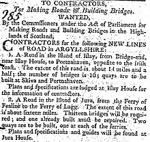
The road was completed in 1806 following the route surveyed by John Langlands of Campbeltown.[2]

  1. ^ "Driving directions to High St/A847". Google Maps. Retrieved 23 September 2013.
  2. ^ Walker, Frank Arneil (2005). The Buildings of Scotland. Argyll and Bute. Yale University Press. p. 551. ISBN 9780300096705.

and 8 Related for: A847 road information

Request time (Page generated in 0.7466 seconds.)

A847 road

Last Update:

The A847 road is one of the two principal roads of Islay in the Inner Hebrides off the west coast of mainland Scotland. It connects Bridgend, at a junction...

Word Count : 133

Portnahaven

Last Update:

located at the southern tip of the Rinns at the southern end of the A847 road. The A847 follows the coast from Portnahaven to Port Charlotte and Bridgend...

Word Count : 291

Easter Ellister

Last Update:

Islay on Islay in the Inner Hebrides of Scotland. It lies just off the A847 road between Portnahaven and Port Charlotte. Wikimedia Commons has media related...

Word Count : 68

Nerabus

Last Update:

for its scenic qualities and diverse birdlife. Nerabus lies along the A847 road on the route from Port Charlotte to Portnahaven. The locale has an early...

Word Count : 109

A roads in Zone 8 of the Great Britain numbering scheme

Last Update:

List of A roads in zone 8 in Great Britain starting north of the A8 and west of the A9 (roads beginning with 8). B roads in Zone 8 of the Great Britain...

Word Count : 51

A846 road

Last Update:

Jura and Islay Port Askaig Keills Ballygrant Bridgend (junction with the A847) Bowmore Glenegedale Port Ellen Laphroaig Lagavulin Ardbeg "Driving directions...

Word Count : 186

B roads in Zone 8 of the Great Britain numbering scheme

Last Update:

B roads are numbered routes in Great Britain of lesser importance than A roads. See the article Great Britain road numbering scheme for the rationale behind...

Word Count : 71

Islay

Last Update:

the A846 from Ardbeg to Port Askaig via Port Ellen and Bowmore, and the A847 which runs down the east coast of the Rhinns. The island has its own bus...

Word Count : 11821

PDF Search Engine © AllGlobal.net