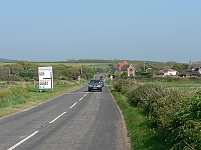
Military Road at Brook. This is the end of the clearway section, as denoted by the signs near the junction. The destination on the sign is Ventnor: despite the fact the road goes to Ryde, motorists travelling there would have a shorter journey via Brook Village and Newport
Major junctions
North end
Ryde
Major intersections
A3054 A3020 A3056 A3054
West end
Totland
Location
Country
United Kingdom
Constituent country
England
Road network
Roads in the United Kingdom
Motorways
A and B road zones
The A3055 is an A-Class Road on the Isle of Wight in Southern England. It forms the Southern portion of the circular around-the-Island A-class loop, the northern section being the A3054. The stretch along the south-west coast of the Island is formed by the Military Road.
Because of the road's relatively short length, there are no confirmatory signs with distances, although on a few direction signs at junctions there are distances to the next town. The final destination of the road (Freshwater/Totland or Ryde), in common with most UK roads, is not signed along the whole length of the route. As well as fitting with national practice, this is also because anybody wishing to travel from Totland to Ryde by road would do so via the North coast A3054, as it is much more direct.
Numerous landslips have affected the road in recent history, particularly around Undercliff Drive between Ventnor and Niton, which has resulted in sections being closed for repair on several occasions.
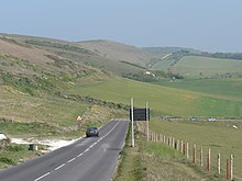
Military Road near Compton Farm (ahead). Automatically in the event of a landslide, or manually in very poor weather, the sign (to the right here) can be illuminated to close the road at this vulnerable point.
The A3055 is an A-Class Road on the Isle of Wight in Southern England. It forms the Southern portion of the circular around-the-Island A-class loop, the...
surmounted by a round barrow. At the eastern foot of the down, on the A3055road between Bonchurch and Luccombe, a path descends into Bonchurch Landslips...
the Isle of Wight Coastline of the United Kingdom Battle of Bonchurch A3055road "Ventnor". City Population. Retrieved 16 September 2023. "Ventnor: Gateway...
Down on the main A3055road. Bonchurch is situated on a stable section of former landslip, its main street (Bonchurch Village Road) running east–west...
Chine and Linstone Chine. Colwell Bay is on the A3054 road and near the western end of the A3055road. Public transport to the area is provided by Southern...
roads in zone 3 in Great Britain starting west of the A3 and south of the A4 (roads beginning with 3). Wikimedia Commons has media related to A roads...
who was succeeded by Chris Kidd. The garden is located alongside the A3055road, and buses on Southern Vectis' Route 6 stop nearby in Park Avenue. There...
A section of the A3055road built as part of the regional fortification on the Isle of Wight in the late 19th century. Military Road (Northumberland)...
circular cycle route used for the annual "Bicycle Island Randonée". The main A3055road from Ryde to Sandown passes through the town. The town is well-connected...
councillor Vanessa Churchman. The settlement lies to the west of the A3055road. Haylands is approximately 5.5 miles (8.9 km) north-east of Newport. Southern...
being the A3055. It connects Newport and Ryde, the two largest towns on the Island, as well as continuing to West Wight. Because of the road's relatively...
The A345 is a secondary A road in Wiltshire, England running from Salisbury to Marlborough and the A4. The road is a main south–north link across Salisbury...
runs from the hamlet of Chilton Green down to the A3055 Military Road where it passes under the road and continues for about 200m to the beach at Brighstone...
Wight, off the south coast of England. The hamlet lies to the east of the A3055road, near to the larger settlement of Freshwater . Afton park is approximately...
The road then follows the Semington bypass, opened in 2004, to Westbury, crossing the A361 between Trowbridge and Devizes. This section of the road has...
B roads are numbered routes in Great Britain of lesser importance than A roads. See the article Great Britain road numbering scheme for the rationale behind...
at Ealing Studios and on location on the Isle of Wight, off Military RoadA3055, between the villages of Afton and Brighstone. Richard "Richie" Twat and...
created by stream erosion of soft Cretaceous rocks. It runs from the A3055 Military Road about 300m due West to the beach at Brook Bay just south of Hanover...
The A381 road is a non-trunk 'A'-class road in Devon, England which serves as an important link between the towns of Teignmouth, Kingsteignton, Newton...
southern edge of Brighstone and runs south-west, crosses under the A3055 Military Road at the hamlet of Marsh Green then continues for about five hundred...
community is mainly based on the A3055 Marlborough Road, with additional shopping facilities in nearby Somerset Road. Public transport is provided by...
Farm between 1557 and 1636. It is reached from a car park on the A3055 coastal road, where a stream running parallel to the cliff takes a right-angled...
the larger Shepherd's Chine. It starts just off the side of the A3055 Military Road and runs south west for about 250m to reach the beach at Brighstone...
 Global Information