 Global Information
Yukon River information
| Yukon River | |
|---|---|
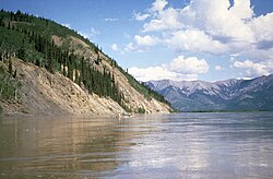 Canoeing the Yukon River | |
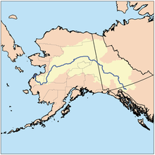 Location of the Yukon River and watershed | |
| Native name |
|
| Location | |
| Countries |
|
| State | Alaska |
| Province/Territory |
|
| Physical characteristics | |
| Source | Llewellyn Glacier at Atlin Lake |
| • location | Atlin District, British Columbia, Canada |
| • coordinates | 59°10′N 133°50′W / 59.167°N 133.833°W |
| • elevation | 669 m (2,195 ft)[1] |
| Mouth | Bering Sea |
• location | Kusilvak, Alaska, U.S. |
• coordinates | 62°35′55″N 164°48′00″W / 62.59861°N 164.80000°W |
• elevation | 0 m (0 ft) |
| Length | 3,190 km (1,980 mi) |
| Basin size | 833,232 km2 (321,713 sq mi) to 854,700 km2 (330,000 sq mi)[2] |
| Width | |
| • average | 0.8 km (0.50 mi) Rampart to Tanana;[3] 820 m (2,690 ft) to 1,000 m (3,300 ft) (Pilot Station)[4] |
| Depth | |
| • average | 9.1 m (30 ft)-12.1 m (40 ft) (Rampart to Tanana);[3] |
| • maximum | 40 m (130 ft) (Rampart);[3] 24.4 m (80 ft) (Pilot Station)[4] |
| Discharge | |
| • location | Pilot Station, Alaska, U.S.— (121 miles upstream of mouth; Basin size: 820,856 km2 (316,934 sq mi);[5] 831,386 km2 (321,000 sq mi)[2][6] |
| • average | (Period of data: 2000/10/01–2023/09/30) 6,860.3 m3/s (242,270 cu ft/s)[7]
(Period of data: 1971–2015) 6,576 m3/s (232,200 cu ft/s)[5] (Period of data: 1977–2006) 6,428 m3/s (227,000 cu ft/s)[8] |
| • minimum | 340 m3/s (12,000 cu ft/s) |
| • maximum | 24,600 m3/s (870,000 cu ft/s) 34,000 m3/s (1,200,000 cu ft/s) (2005)[7] |
| Discharge | |
| • location | Yukon Delta, U.S., Alaska, Bering Sea |
| • average |
|
| Discharge | |
| • location | Kaltag (450 miles upstream of mouth; Basin size: 767,000 km2 (296,000 sq mi)[2] |
| • average | 6,040.2 m3/s (213,310 cu ft/s)[6] to 6,130.6 m3/s (216,500 cu ft/s)[2] |
| Discharge | |
| • location | Stevens Village (Basin size: 508,417 km2 (196,301 sq mi)[6] |
| • average | (Period of data: 1977–2022) 3,471.1 m3/s (122,580 cu ft/s)[2] |
| Discharge | |
| • location | Dawson (1,300 miles upstream of mouth; Basin size: 264,000 km2 (102,000 sq mi)[6] |
| • average | 2,160 m3/s (76,000 cu ft/s)[6] to 2,319.1 m3/s (81,900 cu ft/s)[9] |
| Basin features | |
| Tributaries | |
| • left | White, Fortymile, Birch Creek, Tanana, Nowitna, Innoko |
| • right | Tagish River, Atlin, Teslin, Big Salmon, Pelly, Stewart, Klondike, Porcupine, Christian, Chandalar, Melozitna, Koyukuk, Anvik, Atchuelinguk, Andreafsky |
| [10][11] | |
The Yukon River is a major watercourse of northwestern North America. From its source in British Columbia, it flows through Canada's territory of Yukon (itself named after the river). The lower half of the river continues westward through the U.S. state of Alaska. The river is 3,190 kilometres (1,980 mi)[11][12] long and empties into the Bering Sea at the Yukon–Kuskokwim Delta. The average flow is 6,400–7,000 m3/s (230,000–250,000 cu ft/s).[2] The total drainage area is 833,000 km2 (321,500 sq mi),[2] of which 323,800 km2 (125,000 sq mi) lies in Canada.[13] The total area is more than 25% larger than Texas or Alberta.
The longest river in Alaska and Yukon, it was one of the principal means of transportation during the 1896–1903 Klondike Gold Rush. A portion of the river in Yukon—"The Thirty Mile" section, from Lake Laberge to the Teslin River—is a national heritage river and a unit of Klondike Gold Rush International Historical Park.[14][15] Paddle-wheel riverboats continued to ply the river until the 1950s, when the Klondike Highway was completed. After the purchase of Alaska by the United States in 1867, the Alaska Commercial Company acquired the assets of the Russian-American Company and constructed several posts at various locations on the Yukon River.
The Yukon River has a recent history of pollution from military installations, dumps, wastewater, and other sources.[16][failed verification][citation needed] However, the Environmental Protection Agency does not list the Yukon River among its impaired watersheds, and water-quality data from the U.S. Geological Survey shows relatively good levels of turbidity, metals, and dissolved oxygen.[17] The Yukon and Mackenzie rivers have much higher suspended sediment concentrations than the great Siberian Arctic rivers.[18]
The Yukon River Inter-Tribal Watershed Council, a cooperative effort of 70 First Nations and tribes in Alaska and Canada, has the goal of making the river and its tributaries safe to drink from again by supplementing and scrutinizing government data.
- ^ "Atlin Lake". Peakbagger.com. Retrieved 11 October 2020.
- ^ a b c d e f g "USGS".
- ^ a b c "Yukon River Panel".
- ^ a b "Yukon (Pilot) River".
- ^ a b Stadnyk, Tricia A.; Tefs, A.; Broesky, M.; Déry, S. J.; Myers, P. G.; Ridenour, N. A.; Koenig, K.; Vonderbank, L.; Gustafsson, D. (2021). "Changing freshwater contributions to the Arctic". Elementa: Science of the Anthropocene. 9. doi:10.1525/elementa.2020.00098. S2CID 236682638.
- ^ a b c d e "GRDC".
- ^ a b "USGS 15565447 YUKON R AT PILOT STATION AK".
- ^ a b c d "River Discharge". Arctic.noaa.gov. Archived from the original on 13 August 2022. Retrieved 11 June 2022.
- ^ "Rivers Network".
- ^ Brabets, Timothy P; Wang, Bronwen; Meade, Robert H. (2000). "Environmental and Hydrologic Overview of the Yukon River Basin, Alaska and Canada" (PDF). United States Geological Survey. Retrieved 5 March 2010.
- ^ a b Yukon River at the Encyclopædia Britannica
- ^ "Yukoninfo.com". Yukoninfo.com. Archived from the original on 2013-10-24. Retrieved 2013-08-18.
- ^ Walvoord, Michelle A.; Striegl, Robert G. (2007-06-28). "Increased groundwater to stream discharge from permafrost thawing in the Yukon River basin: Potential impacts on lateral export of carbon and nitrogen". Geophysical Research Letters. 34 (12): L12402. doi:10.1029/2007GL030216. ISSN 0094-8276. S2CID 128894194.
- ^ The Thirty Mile (Yukon River) National Heritage River Archived January 6, 2011, at the Wayback Machine, National Heritage Rivers System
- ^ Klondike Gold Rush International Historical Park Archived October 9, 2012, at the Wayback Machine, Parks Canada
- ^ "Earth Snapshot • Yukon River". Eosnap.com. Archived from the original on 2020-10-27. Retrieved 2018-02-09.
- ^ "USGS Water Quality Samples – 1 sites found". Nwis.waterdata.usgs.gov. Retrieved 2013-08-18.
- ^ "Arctic Great Rivers Observatory". Arctic Great Rivers. Retrieved 2018-04-10.