The neutrality of this article is disputed. Relevant discussion may be found on the talk page. Please do not remove this message until conditions to do so are met.(September 2021) (Learn how and when to remove this template message)
Woreda in Tigray, Ethiopia
Tselemti
ጸለምቲ(Tigrinya)
Woreda
Country
Ethiopia
Region
Tigray
Zone
Semien Mi'irabawi (North Western)
Administrative center
Mai Tsebri
Area
• Total
3,858.66 km2 (1,489.84 sq mi)
Population
(2017)
• Total
158,000
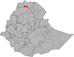
Tselemti (Tigrinya: ጸለምቲ, lit. 'blackish') is an Ethiopian District, or woreda, in the Tigray Region of Ethiopia.[1] Part of the Semien Mi'irabawi (North Western) Zone, Tselemti is bordered on the south by the Amhara Region, on the west by the Mi'irabawi Zone, on the north by Asigede Tsimbela, on the northeast by Medebay Zana, and on the east by the Maekelay (Central Area) Zone. The Tekezé defines the boundary between Tselemti and both the last two woredas and the Zone; other rivers in this woreda include the Abata, a tributary of the Tekezé. The administrative center of this woreda is Mai Tsebri; other towns in Tselemti include Dima.
^C.F. Beckingham and G.W.B. Huntingford, Some records of Ethiopia, 1593-1646 (London: Hakluyt Society, 1954), p. 243. The earliest surviving mention of this area is in the Futuh al-Habasha, written shortly after 1559. (Sihab ad-Din Ahmad bin 'Abd al-Qader, Futuh al-Habasa: The conquest of Ethiopia, translated by Paul Lester Stenhouse with annotations by Richard Pankhurst [Hollywood: Tsehai, 2003], p. 84). Huntingford, George Wynn Brereton. The Historical Geography of Ethiopia: From the First Century Ad to 1704. Oxford: Oxford University Press, 1989.
Tselemti (Tigrinya: ጸለምቲ, lit. 'blackish') is an Ethiopian District, or woreda, in the Tigray Region of Ethiopia. Part of the Semien Mi'irabawi (North...
Kafta Humera, Tembien, Kilite Awlalo, Raya Azebo, Axum, Tsegede, Adwa, Tselemti and Shire, however areas where Tigrayans have historical links are many...
from Shire to Gondar. The town is also the administrative center of the Tselemti woreda (district). The town's economy is agriculturally focused. "Supplimentary...
mainly on what are today North Gondar Zone, Shire Inda Selassie, Wolqayit, Tselemti, Dembia, Segelt, Quara, and Belesa. The Beta Israel appear to have been...
Tsimbla lie to the north-east, on the other side of the Tekezé River, and Tselemti to the east. The administrative center of Welkait is Addi Remets; other...
Tekezé River and advanced westward, capturing the town of Mai Tsebri in the Tselemti district, and prompting Amhara officials to call on its militias to arm...
south by the Tekeze River which separates the woreda on the south from Tselemti and to the west and northwest by Tahtay Adyabo, on the north by La'ilay...
the same. The names of cities and towns such as Mai Kadra, Mai Tsebri, Tselemti and Addi Remets are Tigrinya further justifying the incorporation of Welkait...
bordered on the south by the Tekeze River which separates Tahtai Adyabo from Tselemti, on the southwest by Asgede Tsimbla, on the northwest by Tahtay Koraro...
south and southwest by the Tekezé River which separates the town from Tselemti and to the west by Tabia Dedebit. To the north is Deguadugugni, and to...
rivers that originate in the highlands of Wolqait, Qafta, Asgede, Tsimbla, Tselemti, Tsegede, and the widely stretched lowlands of Adiabo. Elevation ranges...
south by the Tekeze River which separates the woreda on the south from Tselemti and to the west by the Asgede, then on the northwest by Tahtay Adyabo,...
zone as a whole was divided by its Amharan administration into Telemt (Tselemti), with May Tebri (May Tsebri) as its capital and Humera–Welqayt–Tegede...
 Global Information