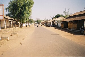
Janjanbureh or Jangjangbureh is a town, founded in 1823, on Janjanbureh Island, also known as MacCarthy Island, in the Gambia River in eastern Gambia.[1][2] Until 1995, it was known as Georgetown and was the second largest town in the country. It is the capital of Janjanbureh Local Government Area (formerly the Central River Division), and the Janjanbureh district. The population of the Janjanbureh LGA was 127,333 at the 2013 population census.[3]
^Gailey, Harry A. (1964). A History of The Gambia. London: Routledge and Kegan Paul.
^Gray, J.M. (1940). History of The Gambia. Cambridge: Cambridge University Press.
^"Distribution of Population by Gender and LGA". GBoS. 2017-09-20. Retrieved 2022-03-10.
Janjanbureh or Jangjangbureh is a town, founded in 1823, on Janjanbureh Island, also known as MacCarthy Island, in the Gambia River in eastern Gambia...
MacCarthy Island, originally known as Lemain Island and officially named Janjanbureh Island, is an island located approximately 170 miles (272 km) upriver...
Upstream view of the river, near Janjanbureh Island Bank of the river, near Janjanbureh Ferry crossing of the river, at Janjanbureh "Gambia River". Encyclopædia...
South and Berending on the north bank. Janjanbureh or Jangjangbureh is a town, founded in 1732, on Janjanbureh Island in the River Gambia in eastern Gambia...
Division is now divided into two LGAs - Kuntaur LGA in the west and Janjanbureh LGA in the east. Each of the other former Divisions has now become an...
his Senegalese mother sent him to live with an aunt in Georgetown (now Janjanbureh) in the Gambia, but he ran away to live on the streets in the capital...
Town may refer to: George, South Africa, formerly known as Georgetown Janjanbureh, Gambia, formerly known as Georgetown Georgetown, Ascension Island, main...
divided into eight local government areas. They are: Banjul Basse Brikama Janjanbureh Kanifing Kerewan Kuntaur Mansakonko Divisions of the Gambia List of local...
Divisions, although the Central River Division was divided into two LGAs, Janjanbureh LGA in the east and Kuntaur LGA in the west. The Local Government Areas...
then to Connecticut in 1989. His father, Lamin Sanneh, was born in Janjanbureh, Gambia, and was a professor of theological history at Yale University...
largest of the five administrative divisions of the Gambia. Its capital is Janjanbureh (formerly Georgetown), on MacCarthy Island. The largest settlement is...
are groups of megalithic stone circles that lie in The Gambia north of Janjanbureh and in central Senegal. Spread across a region 30,000 km2 (12,000 sq mi)...
Although the official government center of the Division is located in Janjanbureh downstream, Bansang has better access to the more affluent coastal region...
Bathurst → Banjul (1973) Georgetown → Janjanbureh James Island → Kunta Kinteh Island (2011) MacCarthy Island → Janjanbureh Island (1995) Lists of renamed places...
A list of buildings and structures in the Gambia: Paradise Suites Hotel, Banjul Kombo Beach Hotel, Kotu Banjul International Airport African Heritage Museum...
no primary schools in Barajally Tenda: the nearest was in Georgetown (Janjanbureh), the provincial capital, but this boarding school was reserved for the...
Armitage Senior Secondary School is a high school located in Janjanbureh, in the Gambia. Armitage a boarding school, is one of the oldest schools in the...
The Senegambian stone circles are megaliths found in Gambia north of Janjanbureh and in central Senegal. The megaliths found in Senegal and Gambia are...
the Gambia from 1966 to 1970. Singahteh was born in Georgetown, modern Janjanbureh, The Gambia, on 13 July 1929. In 1949, she married Sir Farimang Singhateh...
the Central River Division include: Armitage Senior Secondary School, Janjanbureh The Gambia portal Schools portal Education in the Gambia List of universities...
Alhagie H. Sowe (GDC) Seat gain, defeated incumbent Habiboulie K. Jawo Janjanbureh Momodou Ceesay (UDP) Seat gain, defeated incumbent Ebrima M. Sarjo Jarra...
River, about three kilometres south of Wassu and 13 kilometres north of Janjanbureh. The North Bank Road, an important highway crosses Wassu, where the well-known...
 Global Information