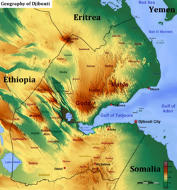
575 km (357 mi) * Ethiopia: 390 km (242 mi) * Eritrea: 125 km (78 mi) * Somalia: 60 km (37 mi) * Yemen: (maritime boundary, Bab el Mandeb)
Highest point
Mousa Ali 2,028 m (6,654 ft)
Lowest point
Lac Assal −155 m (−509 ft)
Largest lake
Lake Abbe
Terrain
Mostly mountainous and volcanic
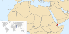
Djibouti is a country in the Horn of Africa. It is bordered by Eritrea in the north, Ethiopia in the west and south, and Somalia in the southeast. To the east is its coastline on the Red Sea and the Gulf of Aden. Rainfall is sparse, and most of the territory has a semi-arid to arid environment. Lake Assal is a saline lake which lies 155 m (509 ft) below sea level, making it the lowest point on land in Africa and the third-lowest point on Earth after the Sea of Galilee and the Dead Sea. Djibouti has the fifth smallest population in Africa. Djibouti's major settlements include the capital Djibouti City, the port towns of Tadjoura and Obock, and the southern cities of Ali Sabieh and Dikhil. It is the forty-six country by area in Africa and 147st largest country in the world by land area, covering a total of 23,200 km2 (9,000 sq mi), of which 23,180 km2 (8,950 sq mi) is land and 20 km2 (7.7 sq mi) is water.[1]
^"Djibouti". The World Factbook. CIA. April 16, 2015. Retrieved April 15, 2015.
and 26 Related for: Geography of Djibouti information
Djibouti is a country in the Horn of Africa. It is bordered by Eritrea in the north, Ethiopia in the west and south, and Somalia in the southeast. To the...
Djibouti (also called Djibouti City and Jibuti in early Western texts) is the capital ofDjibouti. It is located in the coastal Djibouti Region on the...
Djibouti, officially the Republic ofDjibouti, is a country in the Horn of Africa, bordered by Somalia to the south, Ethiopia to the southwest, Eritrea...
following outline is provided as an overview of and topical guide to Djibouti: Djibouti – country located in the Horn of Africa. It is bordered by Eritrea in...
The regions ofDjibouti are the primary geographical divisions through which Djibouti is administered. The first administrative division of the territory...
northwestern Djibouti. Situated in the Afar Triangle, it stretches across 136,956 square kilometres (52,879 sq mi)[citation needed] of arid terrain....
Wayn), Bara Wein or Bada Wein, is a desert in southern Djibouti. It consists of large areas of sand flats, with sparse, semi-desert and desert grasses...
The geology ofDjibouti consists largely of volcanic rocks from the Miocene to Holocene epochs. There are more recent alluvial deposits with coral on...
Djibouti is a country in the Horn of Africa bordered by Somaliland to the east, Eritrea to west and the Red Sea to the north, Ethiopia to the west and...
The economy ofDjibouti is derived in large part from its strategic location on the Red Sea. Djibouti is mostly barren, with little development in the...
provided as an overview of and topical guide to geography: Geography – study of Earth and its people. an academic discipline – a body of knowledge given to...
Fagal (Arabic: فغال) is a coastal location in eastern Djibouti. It lies north of Obock. It lies along the N15 road, connected to the Eritrean border at...
northwest by Sudan, on the south by Ethiopia, and on the southeast by Djibouti. The country has a high central plateau that varies from 1,800 to 3,000...
Indian Ocean between Yemen to the north, the Arabian Sea to the east, Djibouti to the west, and the Guardafui Channel, Socotra and Somalia to the south...
the Suez Canal were obvious targets and an Italian invasion of French Somaliland (Djibouti) or British Somaliland was also feasible. Mussolini looked forward...
(primary coordinates) GPX (secondary coordinates) This is a list of localities in Djibouti ordered by population according to the 2009 census. All settlements...
Television ofDjibouti (RTD) (Arabic: إذاعة وتلفزيون جيبوتي, French: Radiodiffusion télévision de Djibouti) is the national broadcaster ofDjibouti. The station...
Travel. 2012. Retrieved July 24, 2017. "Madagascar-GEOGRAPHY". countrystudies.us. U. S. Library of Congress. Retrieved 15 May 2021. Murray, N.J.; Phinn...
in Djibouti. Geographyof Africa Extreme points of the Earth the Kilimanjaro 2008 Precise Height Measurement Expedition. "Precise Determination of the...
The Djibouti Xeric Shrublands ecoregion is a semi-desert strip on or near the Red Sea and the Gulf of Aden coasts in Eritrea, Ethiopia, Djibouti and Somalia...
Ismailia 27°00′N 30°00′E / 27.000°N 30.000°E / 27.000; 30.000 The geographyof Egypt relates to two regions: North Africa and West Asia. Egypt has coastlines...
Djibouti Region, also known formerly as Djibouti District, is the capital of the Republic ofDjibouti and one of the six regional administrative divisions...
This list of Ports and harbours in Djibouti details the ports, harbours around the coast ofDjibouti. Map all coordinates using OpenStreetMap Download...
livestock). Africa portal List of national parks in Africa Outline of Africa#Geographyof Africa The Horn of Africa One or more of the preceding sentences incorporates...
Djibouti is divided into five administrative regions and one city. The regions are divided into twenty administrative districts. Adailou District Ali Adde...
 Global Information