Turkish Republic of Northern Cyprus (de facto northern administration, self-proclaimed and only recognised by Turkey)
Capital and largest city
North Nicosia
Area covered
3,355 km2 (1,295 sq mi; 36.3%)
Sovereign Base Areas of Akrotiri and Dhekelia (British Overseas Territory)
Capital and largest settlement
Episkopi Cantonment
Area covered
254 km2 (98 sq mi; 2.7%)
Demographics
Population
1,278,686 (2021)
Pop. density
138/km2 (357/sq mi)
Ethnic groups
Greek Cypriots
Turkish Cypriots
Armenian Cypriots
Maronite Cypriots
Cyprus is an island country in the Eastern Basin of the Mediterranean Sea. It is the third-largest island in the Mediterranean, after the Italian islands of Sicily and Sardinia, and the 80th-largest island in the world by area. It is located south of the Anatolian Peninsula, yet it belongs to the Cyprus Arc.[1] Geographically, Cyprus is located in West Asia,[2] but the country is considered a European country in political geography.[3] Cyprus also had lengthy periods of mainly Greek and intermittent Anatolian, Levantine, Byzantine, Turkish, and Western European influence.
The island is dominated by two mountain ranges, the Troodos Mountains and the Kyrenia Mountains or Pentadaktylos, and the central plain, the Mesaoria, between them.[4] The Troodos Mountains cover most of the southern and western portions of the island and account for roughly half its area.[4] The narrow Kyrenia Range extends along the northern coastline.[4] It is not as high as the Troodos Mountains, and it occupies substantially less area.[4] The two mountain ranges run generally parallel to the Taurus Mountains on the Turkish mainland, the outlines of which are visible from northern Cyprus.[4] Coastal lowlands, varying in width, surround the island.[4]
Geopolitically, the island is divided into four segments. The Republic of Cyprus, the only internationally recognized government, occupies the southern 60% of the island, and has been a member state of the European Union since 1 May 2004. The Turkish Republic of Northern Cyprus, is diplomatically recognized only by Turkey; it governs the northern one-third of the island, around 36% of the territory. The United Nations-controlled Green Line is a buffer zone that separates the two and it is about 4%. Lastly, two areas—Akrotiri and Dhekelia—remain under British sovereignty for military purposes, collectively forming the Sovereign Base Areas of Akrotiri and Dhekelia (SBA). The SBAs are located on the southern coast of the island and together encompass 254 km2, or 2.8% of the island.
^ abcdefSolsten, Eric, ed. (1993). Cyprus: a country study (4th ed.). Washington, D.C.: Federal Research Division, Library of Congress. pp. 50–53. ISBN 0-8444-0752-6. OCLC 27014039. This article incorporates text from this source, which is in the public domain.{{cite encyclopedia}}: CS1 maint: postscript (link)
and 28 Related for: Geography of Cyprus information
the Cyprus Arc. Geographically, Cyprus is located in West Asia, but the country is considered a European country in political geography. Cyprus also...
Northern Cyprus, officially the Turkish Republic of Northern Cyprus (TRNC), is a de facto state that comprises the northeastern portion of the island of Cyprus...
Cyprus (/ˈsaɪprəs/ ), officially the Republic ofCyprus, is an island country in the eastern Mediterranean Sea, north of the Sinai Peninsula, south of...
officially the Sovereign Base Areas of Akrotiri and Dhekelia (SBA), is a British Overseas Territory on the island ofCyprus. The areas, which include British...
See ISO 3166-2:CY Internet country code top-level domain: .cy GeographyofCyprusCyprus is: an island country Location: Northern Hemisphere and Eastern...
Cyprus has a subtropical climate - Mediterranean and semi-arid type - Csa and BShaccording to Köppen climate classification, with very mild winters on...
Turkish invasion ofCyprus began on 20 July 1974 and progressed in two phases over the following month. Taking place upon a background of intercommunal violence...
municipalities and communities. The districts ofCyprus are listed in the table below. Note: Northern Cyprus-controlled lands are included in the area figures...
Human habitation ofCyprus dates back to the Paleolithic era. Cyprus'sgeographic position has caused Cyprus to be influenced by differing Eastern Mediterranean...
Levant. The island of Cyprus is also included as a third subregion in the archaeological region of the Levant: Cyprus, geographically distinct from the Levant...
Cyprus problem, also known as the Cyprus conflict, Cyprus issue, Cyprus dispute, or Cyprus question, is an ongoing dispute between the Greek Cypriot community...
The Kingdom ofCyprus (French: Royaume de Chypre; Latin: Regnum Cypri) was a medieval kingdom of the Crusader states that existed between 1192 and 1489...
The people ofCyprus are broadly divided into two main ethnic communities, Greek Cypriots and Turkish Cypriots, who share many cultural traits but maintain...
British Cyprus (Greek: Βρετανική Κύπρος; Turkish: İngiliz Kıbrıs) was the island ofCyprus under the dominion of the British Empire, administered sequentially...
January Clean Monday – date variable Greek Independence Day – 25 March Cyprus National Day – 1 April Good Friday – date variable Holy Saturday – date...
provided as an overview of and topical guide to geography: Geography – study of Earth and its people. an academic discipline – a body of knowledge given to...
languages of the Republic ofCyprus are Greek and Turkish.: art. 3, § 1 The everyday spoken language (vernacular) of Greek Cypriots is Cypriot Greek, and...
are ethnic Turks originating from Cyprus. Turkish Cypriots are mainly Sunni Muslims. Following the Ottoman conquest of the island in 1571, about 30,000...
island ofCyprus and claimed by the state ofCyprus. The map shows one of the most commonly accepted delineations of the geographical boundaries of Europe...
Protection of the Traditional Cheese ofCyprus named Halloumi. It is also protected as a geographical indication in the EU, as a Protected Designation of Origin...
ofCyprus (Greek: Εθνική Φρουρά), also known as the Greek Cypriot National Guard or simply National Guard, is the military force of the Republic of Cyprus...
of Europe or through submarine pipelines starting from Israel and then leading to Greece via Cyprus. GeographyofCyprus Exclusive economic zone of Greece...
economy ofCyprus is a high-income economy as classified by the World Bank, and was included by the International Monetary Fund in its list of advanced...
The national flag ofCyprus (Greek: Σημαία της Κύπρου, romanized: Simaía tis Kýprou; Turkish: Kıbrıs bayrağı) came into use on 16 August 1960, under the...
 Global Information
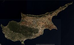

 This article incorporates text from this source, which is in the public domain.