For other uses, see Cape of Good Hope (disambiguation).
Not to be confused with Cape Point or Cape Agulhas.
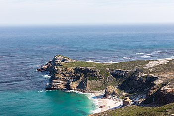
The Cape of Good Hope looking towards the west, from the coastal cliffs above Cape Point, overlooking Dias beach
The Cape of Good Hope (Afrikaans: Kaap die Goeie Hoop[ˌkɑːpdiˌχujəˈɦuəp])[a] is a rocky headland on the Atlantic coast of the Cape Peninsula in South Africa.
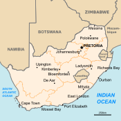
A common misconception is that the Cape of Good Hope is the southern tip of Africa, based on the misbelief that the Cape was the dividing point between the Atlantic and Indian oceans. In fact, the southernmost point of Africa is Cape Agulhas about 150 kilometres (90 mi) to the east-southeast.[1] The currents of the two oceans meet at the point where the warm-water Agulhas current meets the cold-water Benguela current and turns back on itself. That oceanic meeting point fluctuates between Cape Agulhas and Cape Point (about 1.2 kilometres (0.75 mi) east of the Cape of Good Hope).
75km 50miles
Cape Agulhas
Cape of Good Hope
The Cape of Good Hope at the southern tip of the Cape Peninsula, approximately 50 km (31 mi) south of Cape Town, South Africa. Cape Agulhas is the southernmost part of South Africa.
When following the western side of the African coastline from the equator, however, the Cape of Good Hope marks the point where a ship begins to travel more eastward than southward. Thus, the first modern rounding of the cape in 1487 by Portuguese explorer Bartolomeu Dias was a milestone in the attempts by the Portuguese to establish direct trade relations with the Far East (although Herodotus mentioned a claim that the Phoenicians had done so far earlier).[2] Dias called the cape Cabo das Tormentas ('Cape of Storms'; Dutch: Stormkaap), which was the original name of the cape.[3]
As one of the great capes of the South Atlantic Ocean, it has long been of special significance to sailors, many of whom refer to it simply as "the Cape".[4] It is a waypoint on the Cape Route and the clipper route followed by clipper ships to the Far East and Australia, and still followed by several offshore yacht races.
The term Cape of Good Hope is also used in three other ways:
It is a section of the Table Mountain National Park, within which the cape of the same name, as well as Cape Point, falls. Prior to its incorporation into the national park, this section constituted the Cape Point Nature Reserve.[5]
It was the name of the early Cape Colony established by the Dutch East Indies Company in 1652, on the Cape Peninsula.
Just before the Union of South Africa was formed, the term referred to the entire region that in 1910 was to become the Cape of Good Hope Province (usually shortened to the Cape Province).
Cite error: There are <ref group=lower-alpha> tags or {{efn}} templates on this page, but the references will not show without a {{reflist|group=lower-alpha}} template or {{notelist}} template (see the help page).
^"Cape of Good Hope, South Africa - 360° Aerial Panoramas". Archived from the original on 2011-10-08. Retrieved 2017-02-03.
^The first circumnavigation of Africa Archived 2015-10-16 at the Wayback Machine. livius.org
^Sarah Mytton Maury (1848). Englishwoman In America. p. 33.
^Along the Clipper Way, Francis Chichester; page 78. Hodder & Stoughton, 1966. ISBN 978-0-340-00191-2
^"Map of the Park, showing the Cape of Good Hope section (retrieved 27 March 2010)". Archived from the original on 1 December 2022. Retrieved 28 March 2010.
Cape Colony (Dutch: Kaapkolonie), also known as the CapeofGoodHope, was a British colony in present-day South Africa named after the CapeofGood Hope...
Parliament of the CapeofGoodHope functioned as the legislature of the Cape Colony, from its founding in 1853, until the creation of the Union of South Africa...
The Castle ofGoodHope (Dutch: Kasteel de Goede Hoop; Afrikaans: Kasteel die Goeie Hoop) is a bastion fort built in the 17th century in Cape Town, South...
the CapeofGoodHope on the southwest corner. Although these two rocky capes are very well known, neither cape is actually the southernmost point of the...
50miles Cape Agulhas CapeofGoodHopeCape Agulhas is located in the Overberg region, 170 kilometres (105 mi) southeast ofCape Town. The cape was named...
astronomer at the CapeofGoodHope was awarded the Royal Medal on two occasions; the first to Thomas Maclear in 1869 for measurement of an arc of the meridian...
the Cape Route, is a shipping route from the European coast of the Atlantic Ocean to Asia's coast of the Indian Ocean passing by the CapeofGoodHope and...
expedition launched in 1795 against the Dutch Cape Colony at the CapeofGoodHope. The Dutch colony at the Cape, established and controlled by the United...
Good Hope). CapeofGoodHope Government Gazette 2318 (28 November 1850) : Proclamation dated 26 November 1850. Act 3 of 1855 (CapeofGoodHope). Cape Town...
since the late 18th century, and in South Africa in the CapeofGoodHope since at least the start of the 19th century. Widely introduced in the 20th century...
elected president of South Africa and Archbishop Desmond Tutu. Founded in 1873 as the University of the CapeofGoodHope, the University of South Africa (or...
around the Antarctica continent, passing south of Cape Horn, CapeofGoodHope and Cape Leeuwin. Since 1918 the Panama Canal is an option but the locks...
Established in 1872, the CapeofGoodHope SPCA (Society for the Prevention of Cruelty to Animals) in Cape Town is the founding society of the SPCA movement...
Goodhope, West Virginia GoodHope, Wisconsin GoodHope, U.S. Virgin Islands CapeofGoodHope, South Africa GoodHope, Botswana GoodHope, Dominica Goodhope...
ofGoodHope, becoming the economic and cultural hub of the Cape Colony. Until the Witwatersrand Gold Rush and the development of Johannesburg, Cape Town...
great capes are three major capesof the continents in the Southern Ocean—Africa's CapeofGoodHope, Australia's Cape Leeuwin, and South America's Cape Horn...
park is named; and the CapeofGoodHope, the most southwestern extremity of Africa. Arguments for a national park on the Cape Peninsula, centred on Table...
CapeofGoodHope (Cabo da Boa Esperança) because it symbolized the opening of a sea route from west to east. At the cape, Dias erected the last of their...
 Global Information